Ben Lomond Peak
Elevation: 9,712
Location: Wasatch Range, Utah
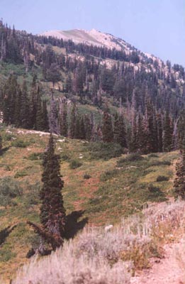
 Ben Lomond is probably the most famous of the northern Wasatch peaks. It
stands north of Ogden in prominent fashion and is very popular with
the community. A couple of well-maintained, but long trails lead to
it's summit. The peak supposedly was what Paramount's logo was designed
from. I've climbed the peak three times, all from the Skyline trail
in North Ogden Canyon. On summer weekends you'll have plenty of company
on the trail.
Ben Lomond is probably the most famous of the northern Wasatch peaks. It
stands north of Ogden in prominent fashion and is very popular with
the community. A couple of well-maintained, but long trails lead to
it's summit. The peak supposedly was what Paramount's logo was designed
from. I've climbed the peak three times, all from the Skyline trail
in North Ogden Canyon. On summer weekends you'll have plenty of company
on the trail.
The trail starts at North Ogden Pass, at an elevation of about 6,200
feet. South is the trail to Lewis Peak, north is the way for Ben Lomond.
It is a long route, 8 miles roughly each way, climbing 3,500 feet. The
trail starts by switchbacking up the south-facing slopes, giving fine
views into Morgan county. Soon upon reaching a ridge, the trail bends
onto the east slope of the mountain, still keeping Ben Lomond from
view. After a while hiking on the east side, the trail crosses the
ridge and Ben Lomond will be clearly visible, still a fair distance
away. The trail stays very gradual here in the pines and in summer
you'll have plenty of wildflowers.
You'll climb gradually to a broad meadow at about 8,700 feet where the
trail from North Fork Park meets the Skyline trail. In 1995 I nearly
stepped right on a fat rattlesnake crossing the trail here (what he
was doing up this high is beyond me). Ben Lomond towers 1,000 feet
above, and a good system of switchbacks will lead you to the peak if
it's late enough in the year and snow does not cover the summit pyramid.
When it does you'll have a much more challenging ascent to the peak,
and a chance for a wondeful glissade down.
 From the peak you'll get a good view west to the Great Salt Lake and
particularly Willard Bay. Further down the ridge is the slightly higher
Willard Peak. You'll be able to see peaks from the Logan area to the
north, and you'll have a commanding view south back through Weber
and Davis counties, and on a clear day you should be able to make out
the high peaks of Salt Lake County far off on the horizon. A large
plaque marks the peak, and inside is a summit register usually. In 1998
I climbed the peak on the way to Willard and found a group camped out
on the summit for the state's 24th of July holiday. Evidently they
watched the fireworks from the summit. Snow lingers on the higher parts
of this peak usually to about the first of July.
From the peak you'll get a good view west to the Great Salt Lake and
particularly Willard Bay. Further down the ridge is the slightly higher
Willard Peak. You'll be able to see peaks from the Logan area to the
north, and you'll have a commanding view south back through Weber
and Davis counties, and on a clear day you should be able to make out
the high peaks of Salt Lake County far off on the horizon. A large
plaque marks the peak, and inside is a summit register usually. In 1998
I climbed the peak on the way to Willard and found a group camped out
on the summit for the state's 24th of July holiday. Evidently they
watched the fireworks from the summit. Snow lingers on the higher parts
of this peak usually to about the first of July.
For more information about traversing over to Willard Peak please see
that trip report, but rest assured, it makes for a long day. The
descent from Ben Lomond is easy and pleasant up high, but in the
heat of the afternoon the lower switchbacks (which face south) catch
the sun at full blast. The hike is also long enough that the trip down
may seem like it takes forever if you're tired. Roundtrip time for the
hike to Ben Lomond is probably between five and eight hours typically. I
hope to climb the peak next time from North Park for something a little
bit different.
Ben Lomond is certainly one of the most enjoyable climbs in the
northern Wasatch, in fact, I would say it is the best peak climb in
that region. It may lack the high altitude characteristics of the
higher peaks to the south, but the scenery is outstanding, and the
relatively gentle grade of the hike make it a great hike if you're in
the mood for a long but pretty walk.
 2002 Update: Hiked Ben Lomond (to saddle, intersect w/Skyline Trail) via North Fork Park. Had some
serious difficulty finding the trailhead. First, I drove all the way up Ogden Canyon only
to find the road closed (thanks, UDOT). I drove back to Ogden and over North Ogden Pass
to the town of Liberty. Still, finding the trailhead proved difficult in the large North
Fork Park area. The trailhead is quite early on...if you're driving around campgrounds on
dirt roads, you've gone too far! The parking lot is a huge field next to a horse corral.
2002 Update: Hiked Ben Lomond (to saddle, intersect w/Skyline Trail) via North Fork Park. Had some
serious difficulty finding the trailhead. First, I drove all the way up Ogden Canyon only
to find the road closed (thanks, UDOT). I drove back to Ogden and over North Ogden Pass
to the town of Liberty. Still, finding the trailhead proved difficult in the large North
Fork Park area. The trailhead is quite early on...if you're driving around campgrounds on
dirt roads, you've gone too far! The parking lot is a huge field next to a horse corral.
The trail is an incredibly long, almost too gentle climb. The first mile or two are quite
rocky, but the trail gets much smoother beyond this. After several miles, the trail makes a turn on
a ridge next to some large cliffs and heads back north towards the finally visible Ben
Lomond Peak. I didn't see any moose in the meadow, but from talking to other people they
are quite common here. Another long series of switchbacks leads up to the saddle, some 6.4 miles
from the trailhead. There are a few junctions, the first leads to an overlook, the second is the intersect
with the trail from the Utaba Camp (shorter and steeper). On this day smoke from the Oregon
fires was filling the skies, making for very poor visibility. I could barely see nearby Mt. Ogden! With
nothing to see, and the late start I called it a day here. My overall thoughts of the North Fork Park
trail are that it is decent, but not as enjoyable as the Skyline Trail.