Flagstaff Mountain
Elevation: 10,530
Location: Wasatch Range, Utah
 Flagstaff Mountain sits behind Alta, just a little ways east on the ridge
from Cardiff Pass. From Big Cottonwood Canyon, the peak is fairly
tucked away. A fairly easy route that I've done multiple times climbs
the peak from Alta. A longer route climbs about eight miles roundtrip, climbing
over 3,000 feet to the peak from Days Fork (Spruces Campground).
Flagstaff Mountain sits behind Alta, just a little ways east on the ridge
from Cardiff Pass. From Big Cottonwood Canyon, the peak is fairly
tucked away. A fairly easy route that I've done multiple times climbs
the peak from Alta. A longer route climbs about eight miles roundtrip, climbing
over 3,000 feet to the peak from Days Fork (Spruces Campground).
The more popular route to the peak from Alta is merely a 3.5 mile
roundtrip hike, gaining about 1,900 feet. Start by taking the trail
to Cardiff Pass. Take the right branch of the road and follow it to
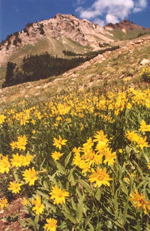
an abandoned old mine on the mountain at about 9,900 feet. In summer, you'll likely find
lots of wildflowers along the way. From the mine you'll have to
ascend 400 feet up the steep, grassy hillside to the ridge above.
The hillside climb is the most challenging part of the climb, and once
you reach the ridge a track will re-appear. Enjoy the great views back down
into Cardiff Fork. Follow this east around a
rocky ridge and ascend the final 200 feet to the summit. With the
route exposed to the sun (south-facing), it is a good climb in June,
and in early-winter when the ski resorts are starting to accumulate
snow. The trip down is easy except for the steepness of the hill that
must be descended. Roundtrip time should only be about three or four hours.
It should be noted that despite the easy climb, the view from Flagstaff
is outstanding. I would say better than Sugarloaf/Baldy/Devils Castle offer.
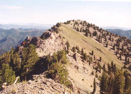
You'll see the rugged Superior/Cardiac ridge to the west. You'll have
a partial view downcanyon, and a clear view of the Pfeifferhorn to the
southwest (see picture). Across the canyon you'll have a full view of
the Alta and Snowbird ski areas. A slightly higher peak sits a little further north, and
getting there is not too difficult, except for a short bit of scrambling near the lower, main
Flagstaff summit. From the ridgeline, you'll be
seperated from Cardiff Pass by a nameless 10,320 foot peak that is quite
rugged and difficult to get over.
 Flagstaff is one of those peaks easy enough and pretty enough to climb
every couple of years. The views, even down lower are very pretty. It
would be a good tune-up for a tougher climb of nearby Mount Superior.
Flagstaff is one of those peaks easy enough and pretty enough to climb
every couple of years. The views, even down lower are very pretty. It
would be a good tune-up for a tougher climb of nearby Mount Superior.
2002 Update: I made two ascents of Flagstaff in July 2002 within five
days of each other. First, on the 20th I made a 4th trip to the peak from Alta via the
standard, short but steep route that most hikers take. Nothing particularly notable other
than the abundance of wildflowers out, but that's not unusual here. On the 24th I decided to
climb the peak via Days Fork in Big Cottonwood, by first climbing the slightly higher "North
Flagstaff" peak (elev. 10,561') and climbing the connecting ridge.
This was the first time I'd hiked up Days Fork, and it did not disappoint. As you enter the Spruces
Campground, the road splits in four directions, take the middle-right road and it will take you to the
trailhead (signed). The trail climbs steeply at the beginning before leveling off where a split
leads to a meadow to the north (Greens Basin). After climbing gently for a while, you come to another meadow where I saw a moose
drinking from the stream nearby. There were many trees here ripped up from the powerful avalanches that
frequent this area. The rugged Reed and Benson ridge towers above to the west. After this
meadow, the trail climbs up the right side of the valley steeply to another meadow, again full of
avalanche debris. Just before reaching the final cirque basin in Days Fork, you'll arrive at the Eclipse
Mine where there is a great deal of old mining equipment still present. Be sure to look back down
the canyon across to the Gobblers Knob/Reynolds Peak area.
 From the cirque basin neither Flagstaff or North Flagstaff stand out, but you can identify them. Flagstaff is
the more rugged peak in the southwest corner, while the higher North Flagstaff is the tree-filled peak due north
of it. Look for the minor ridge leading down from North Flagstaff to the cirque basin. It is a climb of about 900
feet to the summit from the end of the trail. It starts gently, but becomes quite steep as it climbs higher, and
some trekking poles came in quite handy for me. There is a faint trail here, but if you lose it, just look for the
route with the best footing and you should be fine. North Flagstaff has an equally outstanding view. While the view
to the ski areas is not as good, you do get a view down the Reed and Benson ridge, and a view of Twin Peaks through
a notch in the Superior/Cardiac Ridge that you don't get from the Flagstaff summit. Taking the ridge
to the lower, main Flagstaff summit is an easy descent of about 100 feet to the saddle between. The part nearer
to Flagstaff is tricky and involves a short scramble that requires some caution. It is possible to take the ridge
east from Flagstaff around the Days Fork cirque to a trail that leads back to Silver Fork, then back to Days Fork.
Total time for this hike was five hours.
From the cirque basin neither Flagstaff or North Flagstaff stand out, but you can identify them. Flagstaff is
the more rugged peak in the southwest corner, while the higher North Flagstaff is the tree-filled peak due north
of it. Look for the minor ridge leading down from North Flagstaff to the cirque basin. It is a climb of about 900
feet to the summit from the end of the trail. It starts gently, but becomes quite steep as it climbs higher, and
some trekking poles came in quite handy for me. There is a faint trail here, but if you lose it, just look for the
route with the best footing and you should be fine. North Flagstaff has an equally outstanding view. While the view
to the ski areas is not as good, you do get a view down the Reed and Benson ridge, and a view of Twin Peaks through
a notch in the Superior/Cardiac Ridge that you don't get from the Flagstaff summit. Taking the ridge
to the lower, main Flagstaff summit is an easy descent of about 100 feet to the saddle between. The part nearer
to Flagstaff is tricky and involves a short scramble that requires some caution. It is possible to take the ridge
east from Flagstaff around the Days Fork cirque to a trail that leads back to Silver Fork, then back to Days Fork.
Total time for this hike was five hours.