Francis Peak
Elevation: 9,515
Location: Wasatch Range, Utah
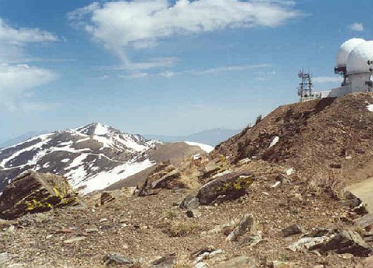
Francis Peak is known to almost any resident in Davis County. It is the prominent peak with
the two huge golf ball like radar stations on it's summit. A popular dirt road leads right
to it's summit, making it easily accessible in summer to anyone. The peak offers a variety
of good hikes and climbs also. I've climbed the peak twice from the road and a partial
climb in early spring from Baer Canyon, the site of a truly killer race in summertime.
 The route up Baer Canyon is a long and hot one. The only time I've hiked up this canyon
was in early spring when the higher part of the mountain was still buried in deep snow. It
is a pretty canyon hike down lower, but the trail was beginning to fade about half way up
the canyon where I stopped. Apparently this route can be followed all the way up to the
ridge just north of the summit, where you can follow the dirt road to the peak. This is
a long hike, climbing about 4,500 feet in four or five miles.
The route up Baer Canyon is a long and hot one. The only time I've hiked up this canyon
was in early spring when the higher part of the mountain was still buried in deep snow. It
is a pretty canyon hike down lower, but the trail was beginning to fade about half way up
the canyon where I stopped. Apparently this route can be followed all the way up to the
ridge just north of the summit, where you can follow the dirt road to the peak. This is
a long hike, climbing about 4,500 feet in four or five miles.
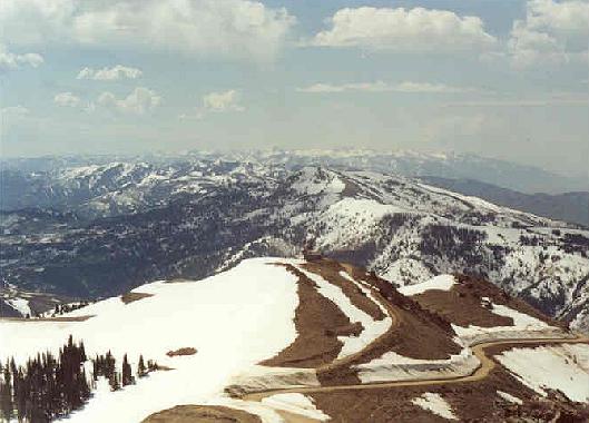
I prefer to drive up Farmington Canyon in late April or early May to where the gate is closed
at about eight miles up the canyon (a switchback, still snowy at this time of year leads
towards Bountiful Peak). From here, it is a walk of about 4.5 miles up the wide, well-maintained
dirt road to the summit. The first mile leads to a garage with a chance to view the Uinta
Mountains to the east. Behind you you'll start to get a good view back towards Bountiful
Peak. As you move higher, Francis Peak will come into view still a few miles away. As you
move higher the piles of snow left from winter will grow taller and taller. I find this
to be a good area for snow climbing/self arrest practice as well.
 As you near the final mile, some parts of the road will have snow as much as 15 feet high
on their side. Because it is a road, it is never very steep, but at this early time of year
it may still be quite cold and icy on the summit. The views are outstanding, and at this
time of year, very wintery still. Between Bountiful Peak and Thurston Peak is surely the
best vantage point for views of the Great Salt Lake. North you'll see the slightly higher
Thurston Peak. To the south behind Bountiful Peak you'll see the full Salt Lake area peaks, still
buried in snow. A large sign greets you upon reaching the peak warning of the hazards of
exposure to radar. Try not to disturb the stations up there.
As you near the final mile, some parts of the road will have snow as much as 15 feet high
on their side. Because it is a road, it is never very steep, but at this early time of year
it may still be quite cold and icy on the summit. The views are outstanding, and at this
time of year, very wintery still. Between Bountiful Peak and Thurston Peak is surely the
best vantage point for views of the Great Salt Lake. North you'll see the slightly higher
Thurston Peak. To the south behind Bountiful Peak you'll see the full Salt Lake area peaks, still
buried in snow. A large sign greets you upon reaching the peak warning of the hazards of
exposure to radar. Try not to disturb the stations up there.
The trip down is routine. In the spring I prefer to find a large snowfield on the west side
of the road and slide down it. It will be obvious by the huge cornices hanging from it about
a mile before the peak. It may not be the most challenging way to climb the peak, but I'm
convinced it is the funnest. I try to climb this or Bountiful Peak early in the season via
their roads each year. The climb is 4.5 miles each way, climbing about 2,300 feet. Plan on
five hours round trip.
2001 Update: Ascended Francis for the third time in three years on May 12th. Took
the same route again from Farmington Canyon starting at about 7,200 feet elevation at 8:20. Reached
the peak at 10:45, about 4.5 miles from the parking lot. Beautiful day, great views in all directions,
but the snow was a little low this year. Some clouds were building but they didn't amount to anything
significant. The road makes for easy walking, but it is long enough
that it shouldn't be taken too lightly.
 On the descent, Allen and I stopped at a huge snowfield to practice some ice axe self-arrests. You
can't miss the hill with it's huge cornices and blocks of fallen snow about a mile below the
peak. Like the Bountiful side, the road up Farmington Canyon is in excellent shape for a dirt
road and I had no problems in my passenger car.
On the descent, Allen and I stopped at a huge snowfield to practice some ice axe self-arrests. You
can't miss the hill with it's huge cornices and blocks of fallen snow about a mile below the
peak. Like the Bountiful side, the road up Farmington Canyon is in excellent shape for a dirt
road and I had no problems in my passenger car.