The Pfeifferhorn is one of the highest and most enjoyable peaks to climb in the Wasatch. The view from the summit is certainly one of the best of any peak in the range. The peak is almost always climbed from the Red Pine Lake area, a ten mile roundtrip climb that gains 3,700 feet. The peak was named after Chuck Pfeiffer, a Wasatch Club leader from long ago.
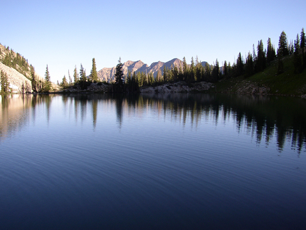
I've climbed the peak three times, first in '95 with the Wasatch Mountain Club in early October, then in September of '97 with John (took the video camera up that time), and most recently in September of 2000 by myself. But perhaps the best place to view the peak is by hiking to nearby Maybird Lakes, where the peak towers above the lake. A far more serious route up the peak exists from the north ridge above these lakes. To get to Maybird Lakes, hike up Red Pine as far as a stream crossing on a bridge. The trail across the stream will take you to Maybird Lakes, a mile or so further. Maybird also offers much more solitude than Red or White Pine Lakes.

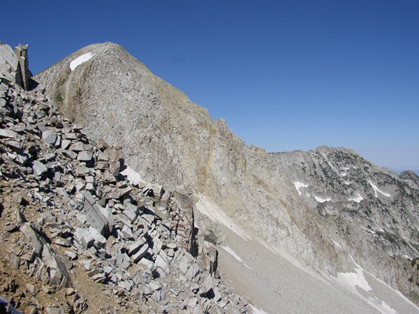
From the upper lake you'll be directly below rugged White Baldy, just five feet lower than the Pfeifferhorn. You'll need to climb the small ridge on the northern side of this upper bench all the way to the crest some 700 feet above. If you're careful you'll find a track leading all the way up, but even then the climb is steep and rocky, and very tiring. Be careful not to get too far off the route because the hillside is filled with large, loose rocks that could come crashing down on you. In spring, this is a popular snow climb, and usually there is a nice cornice at the upper ridge of the already steep slope.

The knife-edge of boulders is not that difficult if you go slowly and cautiously. There are a variety of ways thru the massive granite blocks, most of the route is on the Little Cottonwood side of the ridge. Nevertheless, be careful because many spots have sharp drops that you'll want to avoid. Beyond the knife-edge, you'll now have just 400 feet to go to reach the peak. The remainder of the climb has fragaments of trail up the very steep chute. It's a mix of rocks and grass, and enjoyable climbing without any real dangers. Soon you'll finally arrive on the tiny summit.

My 1995 ascent with the Wasatch club was after a snowstorm earlier in the week had left a few inches on the trail lower, and about a foot of snow on the higher parts. In '97, my climb was just after a storm was clearing and clouds were racing over the peaks while we were on the summit ridge. My 2000 ascent was much like the 1995 one in that a storm earlier had left some early snow on the peak.

2005 Update:My latest climb of the Pfeifferhorn (4th overall) happened quite unexpectedly. For weeks I had been planning on an overnight trip with Allen to climb Cascade Mountain in Utah County and knock off the only real significant Wasatch peak I had not yet climbed. I left work early, met up with Allen and we drove down to Provo Canyon to access the Squaw Peak road. After several miles paved, the road turned to dirt as I had remembered, but after about a mile we reached a rut in the road from the excessive runoff this year that we concluded was impassible in Allen's passenger car. Concluding we were too far from the trailhead to park and start here, we made a quick decision to bag the Cascade Mountain idea and head for another peak nearby, which led us to the popular and scenic Pfeifferhorn via Red Pine Lake route.
We arrived in Little Cottonwood a little later than we had liked, and began the hike to Red Pine Lake with our heavy, full size packs. I rarely "backpack", preferring to day hike peaks wherever possible, and the weight bogged both of us considerably. The bugs were plentiful and darkness came quickly, forcing us to find a spot to camp a couple hundred feet below the lake. Neither of us could sleep well in the cramped tent, and I think we were both thrilled when light came and we could get on the move again. Allen had not yet climbed Pfeifferhorn and I looked forward to getting him his first ascent of this Wasatch classic. We quickly arrived at Red Pine Lake, scenic in the morning light. We continued up behind the lake, now encountering our first snowfield, which was still somewhat icy in the early morning. Soon we gained the upper basin and began the climb of the minor east facing ridge that leads to the Pfeifferhorn/White Baldy ridge (Alpine Ridge). Snow covered much of this, but it was softer having sat in the sun for a while and the climb was easy.
From the ridge, we continued west towards Pfeifferhorn, passing a mountain goat and viewing many more down on the American Fork side of the ridge. The final knife-edge was easy for me to negotiate having been there several times, but Allen disappeared for a bit on what I assume was a wrong turn. We soon finished the steep last section, both reaching the top quite exhausted. We elected not to stay too long despite the great views, as I think we both really just wanted to get the hike over with, and we both knew we had to haul those big packs back out. The trip down was slow and careful as we were both quite tired from the poor night's sleep. Back at the tent, we rested for about 10 minutes, but in the hot sun, we abandoned that idea in favor of getting the hell out of there! A long hike out awaited, and my shoulders were thrilled to get back to the parking lot and get the heavy pack off of them. I still have Cascade to do, but I was happy with the climb of Pfeifferhorn, a higher and more scenic peak.