Grandeur Peak
Elevation: 8,299
Location: Wasatch Range, Utah
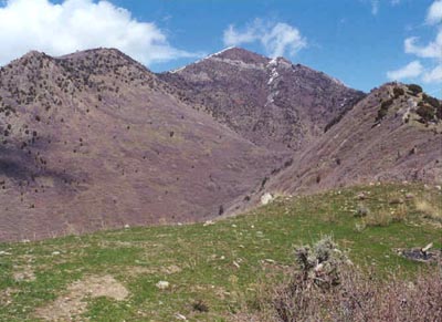 Grandeur Peak sits at the Wasatch Front between Parleys and Mill Creek Canyons. It's summit is a popular destination, and it is
one of those hikes best done on a weekday if possible to get a little more solitude. The peak has two main routes to the summit. The
most popular is via Church Fork in Mill Creek Canyon. A shorter, steeper route is available from above the homes on Grandeur's west
slopes. Either route is enjoyable, but I prefer the Church Fork route as it offers a gentler pitch and more shade. If you decide to do
the Church Fork route don't forget that there is (at this writing) a $2.25 fee per vehicle in Mill Creek Canyon. For Church Fork, simply
drive up Mill Creek about three miles to the signed trailhead. If the gate is open, you may be able to drive right up past the picnic
sites and park at the trailhead, but more likely either the gate will be closed, or the good parking spots in the tiny lot will be taken, and
you'll be forced to park out along the road.
Grandeur Peak sits at the Wasatch Front between Parleys and Mill Creek Canyons. It's summit is a popular destination, and it is
one of those hikes best done on a weekday if possible to get a little more solitude. The peak has two main routes to the summit. The
most popular is via Church Fork in Mill Creek Canyon. A shorter, steeper route is available from above the homes on Grandeur's west
slopes. Either route is enjoyable, but I prefer the Church Fork route as it offers a gentler pitch and more shade. If you decide to do
the Church Fork route don't forget that there is (at this writing) a $2.25 fee per vehicle in Mill Creek Canyon. For Church Fork, simply
drive up Mill Creek about three miles to the signed trailhead. If the gate is open, you may be able to drive right up past the picnic
sites and park at the trailhead, but more likely either the gate will be closed, or the good parking spots in the tiny lot will be taken, and
you'll be forced to park out along the road.
I have climbed Grandeur several times from Church Fork, and it is always enjoyable. I find the first week or two of May to be ideal. The trail starts
by a small waterfall and follows the creek into the fork. Soon it starts a series of switchbacks up the hillside, and behind you to the south you'll
have excellent views of the Mt. Olympus Wilderness Area. After several switchbacks (including an option to leave the trail and climb the slightly higher
Church Fork Peak (elev. 8,306) you'll head back west to the saddle at about 7,800 feet with your first view back to downtown Salt Lake. Beyond the saddle
snow often lingers into early May, but it shouldn't be too difficult to climb as there is usually a track through it on this popular peak. As with most
peaks, the final 500 feet is considerably steeper than the rest of the hike. Once you reach the summit your view of the valley will open up, and you'll
have an outstanding 360 degree view. Don't expect to have the peak to yourself, even on weekdays in May I've found myself sharing the summit with several
people, and it seems to be a favorite amongst scout groups. Looking to the south you'll see Mt. Olympus, Mt. Raymond and Gobblers Knob turning east. On the same
ridge you'll see Church Fork Peak (also accessable by turning east from the 7,800 foot saddle) with Mt. Aire further behind it. To the north you'll be able to easily
see the pointed Grandview Peak, and the mountains of Davis and Weber Counties far in the distance on clear days. The Church Fork route climbs 2,600 feet in three miles (six miles roundtrip) and takes three to four hours typically for me.
 2003 Update:
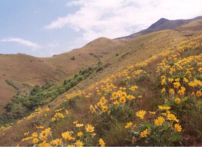
The west ridge route on Grandeur is a short, very steep route to the summit that is available many years in mid-April depending on the
snowmelt. I did this climb on May 18, and ran into minimal snow on just the last 200 feet to the summit, easily negotiated. Taking 3300 south east from Wasatch
Boulevard, continue down the main road north to the obvious parking area. A short trail leads up past homes to two distinct ridges of Grandeur. A steep trail leads
up the southern ridge, while a more gentle trail leads up between the ridges to eventually ascend the northern ridge. My brother-in-law Jason and I ascended the southern
ridge and descended the northern ridge. The trail climbs VERY steeply up the initial first couple of hundred feet, then eases up slightly (I emphasize "slightly") as it
climbs the open ridge, covered in wildflowers to where it meets the northern trail. From several spots the views south towards Mt. Olympus and Wildcat Ridge are
spectacular, especially early in the season when still covered in snow - a stark contrast to the barren west slopes of Grandeur. From where the trails merge, the main
trail continues steeply to the summit. The trail is in generally good condition and easy to follow right to the summit. The descent of the northern ridge is similar
to the south ridge, with several spots of very steep trail, sometimes on slippery, rocky surfaces. This route climbs 3,300 feet to the summit in just over two miles!
2003 Update:
The west ridge route on Grandeur is a short, very steep route to the summit that is available many years in mid-April depending on the
snowmelt. I did this climb on May 18, and ran into minimal snow on just the last 200 feet to the summit, easily negotiated. Taking 3300 south east from Wasatch
Boulevard, continue down the main road north to the obvious parking area. A short trail leads up past homes to two distinct ridges of Grandeur. A steep trail leads
up the southern ridge, while a more gentle trail leads up between the ridges to eventually ascend the northern ridge. My brother-in-law Jason and I ascended the southern
ridge and descended the northern ridge. The trail climbs VERY steeply up the initial first couple of hundred feet, then eases up slightly (I emphasize "slightly") as it
climbs the open ridge, covered in wildflowers to where it meets the northern trail. From several spots the views south towards Mt. Olympus and Wildcat Ridge are
spectacular, especially early in the season when still covered in snow - a stark contrast to the barren west slopes of Grandeur. From where the trails merge, the main
trail continues steeply to the summit. The trail is in generally good condition and easy to follow right to the summit. The descent of the northern ridge is similar
to the south ridge, with several spots of very steep trail, sometimes on slippery, rocky surfaces. This route climbs 3,300 feet to the summit in just over two miles!
A longer alternative still is to hike the Burch Hollow trail which is further east up Mill Creek Canyon to Church Fork Peak, then cross the ridge back west
to Grandeur Peak. This would require a car shuttle or some extra walking after the hike. Burch Hollow is reached via the Pipeline trail and climbs steeply to
the ridge just east of Church Fork Peak. There is no trail to the peak, but it is not too difficult to get there. Grandeur is certainly one of the "classic" hikes
of the Wasatch, and is always a good tune up for bigger hikes. Due to the lower elevation however, it becomes a hike better in early summer or fall, or even at night with
a flashlight. Nearby Rattlesnake Gulch (lower in the canyon) offers a short hike to a scenic overlook of Salt Lake Valley directly under Grandeur Peak and one of the better
views of Mt. Olympus and it's north face. It is also incidently the
spot where I proposed to my wife, and makes an excellent beginner snowshoe trip in winter.
Mt. Aire
Elevation: 8,621
Location: Wasatch Range, Utah
 The ascent to the summit of Mt. Aire is one of my favorites when I'm looking for a short hike to do after
work. From the Elbow Fork trailhead, it is just under two miles to the summit, climbing 1,990 feet. The road
up Mill Creek doesn't open fully until late May most years, so the hike requires either walking up the road or waiting
until the road is opened.
The ascent to the summit of Mt. Aire is one of my favorites when I'm looking for a short hike to do after
work. From the Elbow Fork trailhead, it is just under two miles to the summit, climbing 1,990 feet. The road
up Mill Creek doesn't open fully until late May most years, so the hike requires either walking up the road or waiting
until the road is opened.
The trail goes up about 1/4 of a mile where a split leads to Lambs Canyon Pass. Continuing towards Mt. Aire, the trail climbs
a wooded hillside (crossing a stream along the way on a nice bridge) to reach Mt. Aire pass at about 7,800 feet. From here it is
3/4 of a mile to the summit climbing 820 feet. The views are very good, but in my opinion not quite as good as those found
on Grandeur Peak to the west, though the views towards Mt. Raymond and Gobblers Knob are excellent. It is possible to continue on
the ridge (no trails for the most part, but not too difficult) either further to the east towards Murdock Peak, or back to the west towards Church Fork
Peak and the Burch Hollow area.
The roundtrip time for climbing Aire via Elbow Fork is typically about 2.5 hours for me. Remember, that vehicles are charged
a $2.25 fee for using Mill Creek Canyon on the way out, so come prepared. Mill Creek's trails are very well kept and I wish more of the
local canyons could use a fee such as this, if for no other reason than to keep out the slobs who leave their garbage all over trails. An alternative
to the Elbow Fork route would be to take the trail to Lambs Canyon Pass, and follow Aire's east ridge back to the summit. That would be a fair amount
longer, and once past Lambs Canyon Pass would be off trail, including some bushwhacking, but nothing severe.
Circle-All Peak
Elevation: 8,707
Location: Wasatch Range, Utah
 The hike to Circle-All Peak is one of my favorite short hikes, and one of the better early summer hikes if you're trying to avoid the snow on the
higher peaks. Circle-All sits south of Mt. Raymond in Big Cottonwood Canyon and is best accessed from the Butler Fork trail, located 8.5 miles up Big
Cottonwood on the north side of the road. Follow the Butler Fork trail up past the stream, where it climbs a brutally steep slope before settling down
and gently entering the Mt. Olympus Wilderness Area. The trail goes for a while to a split, where the right branch leads to the Dog Lake area. Staying on the left
branch, the trail starts to climb up a forested hillside in a series of gentle switchbacks (where in the mid 90's a buddy and I encountered some serious beehives!). You'll soon arrive at
the saddle. At the saddle, the main trail continues north towards Mt. Raymond, and a smaller branch takes off to the left (south) towards Circle-All's summit, only about
100 feet higher.
The hike to Circle-All Peak is one of my favorite short hikes, and one of the better early summer hikes if you're trying to avoid the snow on the
higher peaks. Circle-All sits south of Mt. Raymond in Big Cottonwood Canyon and is best accessed from the Butler Fork trail, located 8.5 miles up Big
Cottonwood on the north side of the road. Follow the Butler Fork trail up past the stream, where it climbs a brutally steep slope before settling down
and gently entering the Mt. Olympus Wilderness Area. The trail goes for a while to a split, where the right branch leads to the Dog Lake area. Staying on the left
branch, the trail starts to climb up a forested hillside in a series of gentle switchbacks (where in the mid 90's a buddy and I encountered some serious beehives!). You'll soon arrive at
the saddle. At the saddle, the main trail continues north towards Mt. Raymond, and a smaller branch takes off to the left (south) towards Circle-All's summit, only about
100 feet higher.
The short path leads quickly to the small summit with outstanding views west and south into the Twin Peaks Wilderness Area. I have snowshoed up to this summit
in winter, and there was little avalanche danger except near the highest switchbacks and the final summit cone. Circle-All also makes a nice sidetrip if you're heading
up towards Raymond or Gobblers Knob. By itself, Circle-All is only a 1,600 foot climb in about 1.75 miles from Butler Fork, and takes about two hours roundtrip.
This is another hike that is easily done even if not started until 6pm after a day of work, and I've found early June to be probably the best time of year
for hiking the trail, as the pictures of the higher peaks, still buried in snow, are outstanding. This is certainly one of the best "bang for the buck" hikes
in the entire Wasatch.