Lewis Peak
Elevation: 8,031
Location: Wasatch Range, Utah
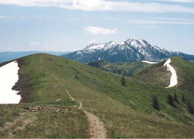 While Lewis Peak sits more than 1,500 feet lower than it's neighbors to the north and south, it is still
a prominent peak in it's own right, and a wonderful day hike with splendid views. The most popular route
starts from North Ogden Pass and uses the well-maintained Skyline Trail for a little over five miles (climbing
a little over 2,000 feet) to the summit. Oddly, one of the bumps along the ridge to Lewis Peak is actually a
few feet higher than Lewis Peak, but it is Lewis, sitting the furthest west along the ridge that got the
name, and offers the best views.
While Lewis Peak sits more than 1,500 feet lower than it's neighbors to the north and south, it is still
a prominent peak in it's own right, and a wonderful day hike with splendid views. The most popular route
starts from North Ogden Pass and uses the well-maintained Skyline Trail for a little over five miles (climbing
a little over 2,000 feet) to the summit. Oddly, one of the bumps along the ridge to Lewis Peak is actually a
few feet higher than Lewis Peak, but it is Lewis, sitting the furthest west along the ridge that got the
name, and offers the best views.
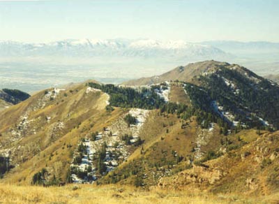
The trail climbs steeply up heavily wooded switchbacks before reaching a ridgeline where it bends and starts to head
back to the west. The trail climbs up and down several small summits along the ridge before reaching Lewis. Since much of
the ridge is rather barren, the views back to the north are excellent of the Ben Lomond/Willard Peak area, and to the south, Mt. Ogden rises sharply. The
west flank of Lewis Peak is quite rugged despite barely reaching 8,000 feet, and there are no trails
that I am aware of that ascend from the valley.
 A longer alternative to climbing Lewis would be to take the long but gradual trail starting at Pineview
Reservoir along the Great Western Trail. After several miles it meets up with the trail coming up from
North Ogden Pass. Along the way you'll pass over the Nordic Valley ski area. The length (about 10 miles each way) makes it more popular with mountain bikers than hikers, but
the scenery, particularly east back towards Pineview Reservoir and the Morgan Valley. Climbing Lewis
via North Ogden Pass took me about five hours roundtrip, and unless you're an Ogden resident, the added drive
will likely make it an all-day hike. Any ascent to the summit via Pineview and the Great Western Trail will
be a full day event.
A longer alternative to climbing Lewis would be to take the long but gradual trail starting at Pineview
Reservoir along the Great Western Trail. After several miles it meets up with the trail coming up from
North Ogden Pass. Along the way you'll pass over the Nordic Valley ski area. The length (about 10 miles each way) makes it more popular with mountain bikers than hikers, but
the scenery, particularly east back towards Pineview Reservoir and the Morgan Valley. Climbing Lewis
via North Ogden Pass took me about five hours roundtrip, and unless you're an Ogden resident, the added drive
will likely make it an all-day hike. Any ascent to the summit via Pineview and the Great Western Trail will
be a full day event.
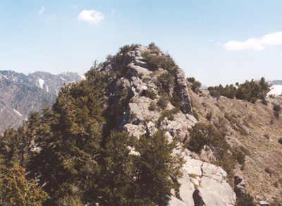
Little Black Mountain
Elevation: 8,040
Location: Wasatch Range, Utah
 Climbed Little Black in May 2004 for the first time in several years. I had forgotten how enjoyable
this peak can be. Starting from the parking area at the top of Terrace Hills Drive, the trail climbs
quickly and meets the Great Western Trail (expect lots of runners and bikers). From here it climbs east around a few turns, and then leaves
the GWT and climbs a steep hillside. Atop this hillside you get a good view of Little Black Mountain, looking
closer than it really is. Continue on the rolling ridge past the popular Avenues Twin Peaks (elev. 6,291'), and you finally
reach the base of Little Black Mountain at roughly 7,200 feet (where some trees finally offer some relief from the sun).
Climbed Little Black in May 2004 for the first time in several years. I had forgotten how enjoyable
this peak can be. Starting from the parking area at the top of Terrace Hills Drive, the trail climbs
quickly and meets the Great Western Trail (expect lots of runners and bikers). From here it climbs east around a few turns, and then leaves
the GWT and climbs a steep hillside. Atop this hillside you get a good view of Little Black Mountain, looking
closer than it really is. Continue on the rolling ridge past the popular Avenues Twin Peaks (elev. 6,291'), and you finally
reach the base of Little Black Mountain at roughly 7,200 feet (where some trees finally offer some relief from the sun).
From here it is a steep climb of about 600 feet to the westernmost summit, marked with a rock cairn and
a USGS benchmark. The elevation here is 7,793 feet and this is not the summit, though the views are excellent. Here a couple of other hikers came up
another ridge after hiking past the site where Elizabeth Smart was kept for several months (not sure of the directions to get there). The ridge continues to climb
gradually to the east. The good trail ends at this first peak, but you can continue east to the higher, true summit. The
ridge becomes gradually rockier and some scrambling with a little exposure is needed to reach the peak. This year there was
still some large snow patches on the north slopes of Little Black, and it made for an enjoyable outing as the views
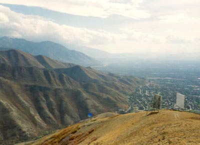
to the south and back to downtown are outstanding. Due to the low elevation and exposure to the sun, this
is not a trip that would be enjoyable in the heat of summer.
 Round trip is just over nine miles, and the elevation gain is 3,100 feet. I will be attempting another
route, far less popular, up Little Black Mountain in the coming weeks. Expect four to five hours at an average
pace.
Round trip is just over nine miles, and the elevation gain is 3,100 feet. I will be attempting another
route, far less popular, up Little Black Mountain in the coming weeks. Expect four to five hours at an average
pace.
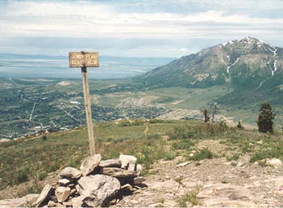
Lookout Peak
Elevation: 8,954
Location: Wasatch Range, Utah
Lookout Peak sits tucked away at the eastern end of the ridge where Little Black Mountain rises. The two most popular routes
to the summit are via Killyon Canyon (accessed from Emigration Canyon) and via Affleck Park (U-65, a little northeast of I-80 in Parley's
Canyon). Both routes converge at Birch Springs Pass and follow the south ridge towards the large, bland summit.
 I climbed Lookout back in the fall of 1997 with John via Killyon Canyon. It was hunting season and already the air was cold
enough that the small stream in Killyon Canyon was partially frozen. Once we reached the pass the sun came out and made our
hike considerably warmer. From Birch Springs Pass it is another 2.5 miles to the summit, climbing 2,200 feet roughly along a
nice trail. As we approached the summit, two hunters on horseback were already there. They left soon after we arrived, and we had the
peak to ourselves and enjoyed the views north to Grandview Peak, and west back down towards Little Black Mountain. To the south
were all the major peaks of the Salt Lake County Wasatch, covered in early winter snow. From Killyon Canyon, the roundtrip climb is eight miles and
climbs about 2,900 feet. The Affleck Park route is about a mile shorter, and has a 2,750 foot vertical climb.
I climbed Lookout back in the fall of 1997 with John via Killyon Canyon. It was hunting season and already the air was cold
enough that the small stream in Killyon Canyon was partially frozen. Once we reached the pass the sun came out and made our
hike considerably warmer. From Birch Springs Pass it is another 2.5 miles to the summit, climbing 2,200 feet roughly along a
nice trail. As we approached the summit, two hunters on horseback were already there. They left soon after we arrived, and we had the
peak to ourselves and enjoyed the views north to Grandview Peak, and west back down towards Little Black Mountain. To the south
were all the major peaks of the Salt Lake County Wasatch, covered in early winter snow. From Killyon Canyon, the roundtrip climb is eight miles and
climbs about 2,900 feet. The Affleck Park route is about a mile shorter, and has a 2,750 foot vertical climb.
With outstanding views in all directions, Lookout is an excellent climb if you're looking for a not-too-difficult climb of a lesser
known Wasatch peak. Expect roundtrip times to be somewhere around four to five hours. If you're climbing via Killyon Canyon in
Emigration Canyon, the trailhead sits amongst some homes. Do your best to park in a way to not disturb them.
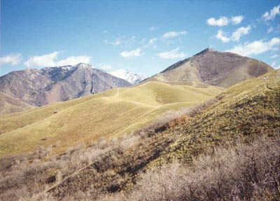
Big Beacon
Elevation: 7,141
Location: Wasatch Range, Utah
This is another example of one of the better spring hikes in the Wasatch, when the higher peaks remain covered in snow. With multiple
ascent options it is a great peak to "get in shape" in spring for the longer hikes available in the summer. Big Beacon (or Mt. Wire on
some older maps) is a prominent peak viewed from most of the Salt Lake Valley. With it's two distinct reflectors, it is easily recognized
from the downtown area.
 The two most popular routes up Big Beacon are via the University of Utah (Georges Hollow) and from Pioneer Park near Hogle Zoo. Both are short
and steep. Most of my ascents have been from the University and I prefer this route. You'll need to get to the Bonneville Shoreline Trail which
runs north-south along this part of the foothills, and there are an ever-changing array of access points. I would reccomend consulting a map to
familiarize yourself with the area so you take the right side trail up Georges Hollow, as there are trails leading everywhere. Once on the proper
trail, it is a steep hike up through the foothills to a false peak just north of Big Beacon. A short walk later and you'll be on the summit. The
reflectors sit just a bit to the south. An old watchtower sits on the summit. To the south is a great view of nearby Mt. Olympus. Roundtrip is about four miles climbing 2,140 feet, assuming you find the right trail!
The two most popular routes up Big Beacon are via the University of Utah (Georges Hollow) and from Pioneer Park near Hogle Zoo. Both are short
and steep. Most of my ascents have been from the University and I prefer this route. You'll need to get to the Bonneville Shoreline Trail which
runs north-south along this part of the foothills, and there are an ever-changing array of access points. I would reccomend consulting a map to
familiarize yourself with the area so you take the right side trail up Georges Hollow, as there are trails leading everywhere. Once on the proper
trail, it is a steep hike up through the foothills to a false peak just north of Big Beacon. A short walk later and you'll be on the summit. The
reflectors sit just a bit to the south. An old watchtower sits on the summit. To the south is a great view of nearby Mt. Olympus. Roundtrip is about four miles climbing 2,140 feet, assuming you find the right trail!
The Pioneer Park route is even shorter and steeper, climbing to the summit in just three miles roundtrip, gaining 2,140 feet. Just east of Pioneer Park
is a trailhead for the Bonneville Shoreline Trail. Again, an array of tracks lead everywhere, but if you can find the right trail it climbs steeply up
the south ridge to the peak. It is possible to hike much further back to the east along this ridge, or hike up Little Black Mountain, head east, and loop
back over Big Beacon and down that way (requiring a car shuttle). Either hike is of the half-day variety. As with much of the Wasatch foothills, keep an
eye out for rattlesnakes.