Mill Canyon Peak
Elevation: 10,349
Location: Wasatch Range, Utah
Mill Canyon Peak is a high and almost completely unknown Wasatch peak. It sits behind
the massive bulk of Mt. Timpanogos and is not seen from the populated valley, however it
is quite clear from parts of the Heber Valley. The peak itself is not very interesting, but
the views from it's slopes are outstanding, particularly of the east side of Mt. Timpanogos.
 The best route to get to Mill Canyon Peak is via American Fork Canyon (exit 287). Take the
standard road up the Alpine Scenic Loop. Stay on the main road past the branch that leads
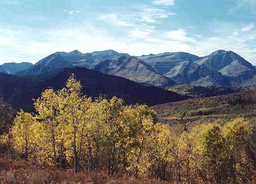
to Tibble Fork and Silver Lake. In fall, the colors are outstanding along this road. A few
miles further (about two miles past the Timpooneke trailhead) is a branch where you can turn left
on the Cascade Springs Road. Take this road, which is actually wider than the Alpine Scenic
Loop road, for about 3.5 miles. An obvious dirt road is on the left (north) side of the road
at a bend. I parked low on the road, but upon walking the first two miles of road, a passenger
car could easily make it to a large, open meadow two miles from the main road.
The best route to get to Mill Canyon Peak is via American Fork Canyon (exit 287). Take the
standard road up the Alpine Scenic Loop. Stay on the main road past the branch that leads
to Tibble Fork and Silver Lake. In fall, the colors are outstanding along this road. A few
miles further (about two miles past the Timpooneke trailhead) is a branch where you can turn left
on the Cascade Springs Road. Take this road, which is actually wider than the Alpine Scenic
Loop road, for about 3.5 miles. An obvious dirt road is on the left (north) side of the road
at a bend. I parked low on the road, but upon walking the first two miles of road, a passenger
car could easily make it to a large, open meadow two miles from the main road.
The lower dirt road is at 7,300 feet. It gains about 900 feet in two miles before joining the
Great Western Trail in a large meadow. All along the way are outstanding views back to Timpanogos, Cascade Peak
and Provo Peak to the south. In fall, this area is full of golden aspens that make it very scenic. Along the two
miles of road are many spots popular for overnight camping. You're certain to see more mountain bikers or motorcycle
riders on this hike than other hikers. From the meadow at 8,200 feet look for an obvious trail heading east while the
dirt road continues northwest.
The trail here is steeper and somewhat rocky as it climbs quickly up to the ridge at about 8,800 feet. Along
the way I saw many deer in this section. Once you make the ridge the terrain flattens briefly before continuing
to ascend the now obvious slope of Mill Canyon Peak. The trail cuts north across the west face of Mill Canyon
Peak gradually climbing to a junction at 9,400 feet just before a rockslide and spring (dry). Here the Great
Western Trail continues north and this could be followed and used for a climb of the peaks pedestrian west ridge. I
opted to take a bend in the trail back south that climbs 300 feet to gain the south ridge at 9,700 feet.
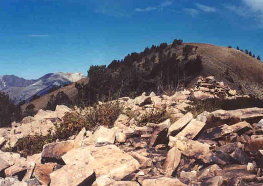
 From the ridge it is a 650 foot climb to the summit. A clear trail leads up the first 200 feet or so, then the
trail fades but it is easy walking up to a small talus field at about 10,160 feet that is easily crossed. From here
it is a breeze to get to the bland peak. The views are outstanding in all directions. North are the peaks of the Alta
and Snowbird ski areas, as well as Red Baldy, White Baldy, Pfeifferhorn and Lone Peak. Box Elder Peak is obvious to
the west. Impressive Mt. Timpanogos dominates the view as you turn south, and Cascade, Provo and Nebo peaks are also visible.
To the east across the Heber Valley are the peaks of the Uinta mountains.
From the ridge it is a 650 foot climb to the summit. A clear trail leads up the first 200 feet or so, then the
trail fades but it is easy walking up to a small talus field at about 10,160 feet that is easily crossed. From here
it is a breeze to get to the bland peak. The views are outstanding in all directions. North are the peaks of the Alta
and Snowbird ski areas, as well as Red Baldy, White Baldy, Pfeifferhorn and Lone Peak. Box Elder Peak is obvious to
the west. Impressive Mt. Timpanogos dominates the view as you turn south, and Cascade, Provo and Nebo peaks are also visible.
To the east across the Heber Valley are the peaks of the Uinta mountains.
It would be easy to descend the west ridge and take the Great Western Trail back the same way you climbed up, making a loop
hike of sorts. My hike was nine miles roundtrip, climbing 3,100 feet. By parking up higher, you can shorten the hike to
about five miles and 2,200 feet of climbing. Mill Canyon was not the type of peak you'd want
to climb repeatedly, but it is worth doing once.