Mount Ogden sits prominently to the east of the community of Ogden, and sits directly behind Weber State University. A variety of trails can be used to access it's summit. The only time I've climbed the peak was via Snowbasin Ski Resort on the east side of the mountain in late summer of 1996. Longer, but more scenic routes can be found on the west side from a variety of canyons, including Beus Canyon, Waterfall Canyon and Taylor Canyon.
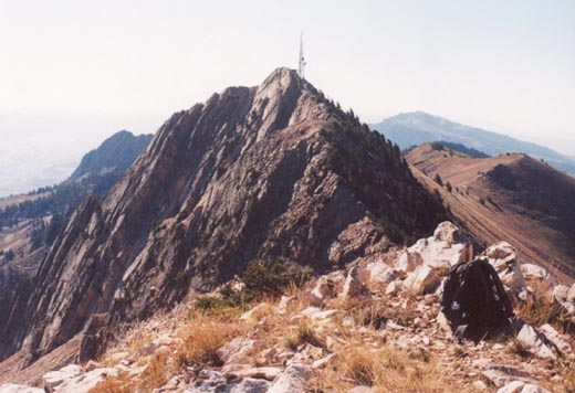
After driving the long, windy road to Snowbasin (probably changed since then to accomidate Olympic traffic), you'll have four miles to reach the top of Mount Ogden. Start hiking up the four-wheel road into the higher country. You may need to do some research of the trails here as like most area ski resorts, things change quickly and often! On my climb I missed a junction, and wound up spending an hour rummaging about too far south of where I needed to be. Assuming you stay on the proper trail, you'll have a clear view of the rocky triangle of Mount Ogden and the towers protruding from it's summit.
You'll have to follow the rocky four-wheel road all the way up some long switchbacks to reach a saddle that drops into Waterfall Canyon on the west. From here, it is a short but steep climb up a few hundred feet of rock to the summit. A plaque marks the popular peak. Oddly enough I had the peak to myself on this day. I pulled out the video camera to take some shots from the summit, but the strong wind made it difficult to hear anything I had said. To the north is a rugged peak, slightly lower called "Allen Peak". To the south are more peaks that are named, but not too popular including DeMoisy Peak and Strawberry Peak. The trip down was much easier than the trip up as I knew which trail to follow now, and it was all on dirt roads.

The climb ends up being eight miles, with a climb of about 3,300 feet from Snowbasin. I've explored Taylor Canyon for a couple of miles in early spring, and it is a very scenic trail that can be climbed 4,500 feet to the summit. A good trail leads to tiny Malans Peak with a fine view of the Ogden area. The trail then bends back to the east and climbs steeply up into Waterfall Canyon to the saddle mentioned above. Waterfall Canyon is a popular hike with locals who enjoy the short trip to the spectacular waterfall in spring and early summer. Ambitous hikers can scramble up a crack through some rocks to get to the higher reaches of Waterfall Canyon and the same trail that starts from Taylor Canyon. In more recent years a trail has been constructed up Beus Canyon (Great Western Trail) all the way to the summit from the southwest. I have no firsthand knowledge of this hike however.
I plan on returning to Mount Ogden hopefully in May or June of 2001 and making a partial snow climb of the mountain for better pictures than the ones I got on a bone-dry late summer day. I'm not sure however which route to take, and I may opt for the popular Taylor Canyon route this next time. Either way, Mount Ogden is an enjoyable day climb.
2002 Update: I made two climbs of Mount Ogden in the late spring and early summer of 2002. First, on Memorial Day I climbed to very near the summit via Beus Canyon, and a few weeks later I made an ascent of the mountain from Snowbasin. I also made another partial climb from Taylor Canyon earlier in the year, stopping at Malans Peak where the snow was becoming far too difficult to continue higher.
The Beus Canyon trail has been improved in recent years, and makes for a nice hike. The trail starts at the top of 46th street where a small parking lot has been created. I hiked the trail in the spring to get familiar with it, and returned on Memorial Day to attempt Mt. Ogden's summit. A note placed on the map indicated that a rattlesnake had made his home along the trail about one mile up. The trail up Beus is very nice as it ascends gently alongside the stream. After about a mile and a half it crosses the stream and ascends more steeply to the ridge seperating Beus and Birch Canyon. Once into Birch Canyon, the trail levels out and climbs gently for several miles up this scenic canyon. As you get near the top of the canyon, you are very close to "DeMoisy Peak", a relatively easy ridge walk from the main ridgeline, despite it's rugged north and east facing cliffs. The Beus trail (really Birch Canyon) fades in this upper bowl, and you have to do some routefinding up the slope to gain the ridgeline. Travel is not difficult up the grassy and rocky slopes, but it is steep! Fresh snow from a recent late spring storm made the climb tedious, and several huge snowfields and cornices kept me from reaching the summit ridge.
The hike back was un-eventful except for running into a baby rattlesnake back in Beus Canyon. I'm not sure if this is the one the sign referred to or not. I took a few pictures as it moved into the bushes, but it seemed to be getting irriated and about ready to strike, so I backed off. The climb up Beus is much longer and difficult than the Snowbasin maintenance roads, but is still a climb I'd reccomend trying once. It is some 4,500 vertical feet to the summit, in about 12 miles roundtrip. Plan on a full day, and a hot hike down in the afternoon. After this hike I developed a nasty cold that lasted for two weeks!
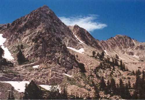
I returned to Mt. Ogden a few weeks later to climb the peak from Snowbasin, with hopes of crossing the ridge to nearby Allen Peak and explore the area used for the 2002 Olympic downhill races. A new road has made access a little easier from the south, and we were quickly at the Snowbasin parking lot (not the Olympic lot further north, and a little lower down). From my previous Snowbasin climb of Ogden years ago, I knew the maintenance roads can be confusing. We headed straight up the main one with Mt. Ogden visible behind the forested ski slopes. After nearly a mile we turned right at a junction and followed that road to the base of the Porcupine lift. From here the road is less obvious as it climbs steeply up for a ways before meeting the more obvious road. From here Mt. Ogden gets more visible and it is easy to follow the road to the saddle just south of Mount Ogden, with some long switchbacks just before the ridge (which were snow-covered). The hike up Snowbasin allows you to see the rugged cirque formed by Mt. Ogden and Allen Peak (elev. 9,465).
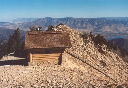
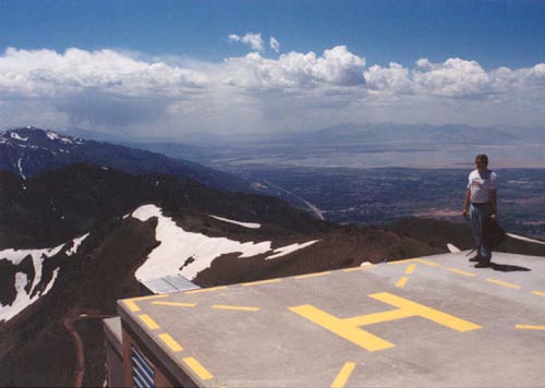
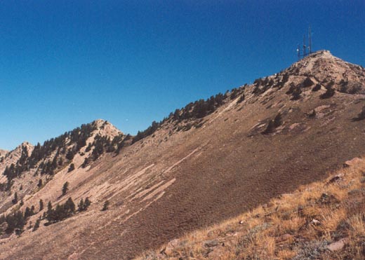
The finish of the Mt. Ogden hike has changed since my 1996 ascent, and there is now more of a road leading up to the summit than the trail years ago. Three radio towers are on the summit now, as well as a helicopter pad! While not particularly asthetically pleasing, the heli-pad makes a nice place to sit and eat lunch, enjoying the great views of the Great Salt Lake and the Wasatch mountains to the south (most notably Thurston Peak). The road finishing up the climb is very steep! As you approach the peak, you'll have to climb around some cemented rocks to get to the southeast side of the peak for the easiest finish to the climb. A couple of other climbers were up there, as well as a number of people who stopped at the saddle to fly some sort of remote control airplanes.
We headed back down to the ridge that leads to Allen Peak. It is rocky, but not as rugged as some of the more notable peaks like Superior or Sundial. We went part way over, but I had made the mistake of bringing my trekking poles, which made it difficult to hang on to the rocks and squeeze past rock outcrops and the trees lining this narrow ridge. The climbing is not difficult, but there are some serious cliffs to the east, so caution is needed. I will probably go back later in the summer or fall and climb Allen Peak from it's northeast ridge, and cross the ridge back to Ogden, this time not bringing the cumbersome poles!
2003 Update: I had been wanting to do the connecting ridge between Mt. Ogden and Allen Peak (one of the more interesting ridges of the northern Wasatch) for some time. With a day off of work and surprisingly good weather for October, I headed up to Snowbasin and made the traverse. I took the standard trail as described above to a junction where I headed north towards a large Olympic complex (great rest area!) with fine views of the rugged east face of Mt. Ogden. After a break, I continued up the trail to the ridge just north of Allen Peak. A jeep road continues right up to the small building which is the starting gate for the 2002 Olympic Men's Downhill. I stopped in, and took a look down the view the skiers had, and much to my surprise, it really wasn't as steep as I had expected it would be. About here the road ends, and a faint trail leads up another hundred feet to the summit of Allen Peak, with a fine view south to Mt. Ogden.
The ridge seperating these two peaks, while nothing spectacular, is probably the most interesting and rugged in the northern Wasatch. A faint trail can be followed in spots, but most of the traverse is picking your way around rocks and steep, grassy slopes being careful not to get too close to the edge on the east (Snowbasin) side where there is significant exposure. About the first half of the traverse stays on or very near the ridge, but as you get closer to Mt. Ogden, the route drops off on the west side to avoid trees on the edge of cliffs. Soon I was on the road just below Mt. Ogden and made the short trip to the summit. After a brief stay, and being ahead of schedule, I hiked down to the saddle to the south where the Snowbasin road meets the trails coming from Beus and Taylor Canyons. Since I abandoned Beus so close the year before I hiked the trail southwest over to the ridge where I had stopped, to essentially complete this route as well. I then backtracked back to the saddle, and down the standard Snowbasin service roads. The fall colors were past their peak, but still fairly abundant.