Mount Peale
Elevation: 12,721
Location: La Sal Range, Utah
 Mount Peale is the highest peak in the La Sal Mountains of southeastern Utah, and
is the highest peak in the state not found in the Uinta Mountains. That alone makes it a fairly
popular climb despite being in an area of low population. The La Sal mountains have
a small but tremendous uplift from the redrock valley floor, and quite possibly the
largest vertical rise of any mountains in Utah (Ibapah, Nebo?). Peale and the La Sals are most commonly
seen in pictures showing Delicate Arch, as the snow-capped mountains in the background.
Mount Peale is the highest peak in the La Sal Mountains of southeastern Utah, and
is the highest peak in the state not found in the Uinta Mountains. That alone makes it a fairly
popular climb despite being in an area of low population. The La Sal mountains have
a small but tremendous uplift from the redrock valley floor, and quite possibly the
largest vertical rise of any mountains in Utah (Ibapah, Nebo?). Peale and the La Sals are most commonly
seen in pictures showing Delicate Arch, as the snow-capped mountains in the background.
Allen and I drove to Moab on July 5, a relatively short 240 mile trip from Salt Lake City. Upon arriving in
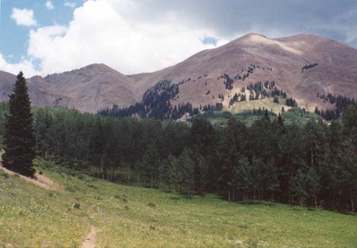
Moab in the afternoon we noted afternoon thunderstorm clouds built up on the La Sal
peaks. We decided to start about as early as possible to avoid these common summer storms. We woke up
on saturday at 6:00 am and drove to the trailhead. The dirt road leading to La Sal pass was in
excellent condition, and was easily passible in a passenger car, except for one small spot where
the creek crosses the road. This however wasn't very deep and was easily driven through. The biggest problem
on the road is the abundance of cattle often loitering on the road. We got to
the pass just before 8:00 am. Jose Knighton's guidebook shows two different routes that converge below
the mountain. We took the route starting at La Sal Pass, where a sign pointed to Mount Peale, clearly
visible in the distance. Also visible and climbable from here is the sharper Mount Tukuhnikivatz (12,482').
 From the pass, you can also see the narrow canyon to the left (west) of Peale that you will need
to get to for the ascent. We saw no trail and began walking cross-country towards the pass through
intermittent stands of aspen and pine trees. On the way down from the peak, we found a trail that begins very near
the pass, that somehow gets lost in the last 200 feet to where cars park (by a wooden fence). If you're lucky, you'll find
the trail right off and avoid the guessing game cross country hike we did. To do this, best bet is to aim north-northeast from the
wooden fence at the pass, rather than heading due north up the obviously open hillside. Nevertheless, we met up with
the route coming up from .7 miles below. A truck was driving right up the dirt road on this route, and in
hindsight, I would probably reccomend this route, especially if you have four-wheel drive and can start higher.
From the pass, you can also see the narrow canyon to the left (west) of Peale that you will need
to get to for the ascent. We saw no trail and began walking cross-country towards the pass through
intermittent stands of aspen and pine trees. On the way down from the peak, we found a trail that begins very near
the pass, that somehow gets lost in the last 200 feet to where cars park (by a wooden fence). If you're lucky, you'll find
the trail right off and avoid the guessing game cross country hike we did. To do this, best bet is to aim north-northeast from the
wooden fence at the pass, rather than heading due north up the obviously open hillside. Nevertheless, we met up with
the route coming up from .7 miles below. A truck was driving right up the dirt road on this route, and in
hindsight, I would probably reccomend this route, especially if you have four-wheel drive and can start higher.
We met up with three other hikers who were also climbing Peale, who had also not been there before. We were able
to find a track through the trees climbing towards the rock gully. Soon, we were getting to mostly rock and
had to move into the gully to avoid the steep talus slopes on the east side. The gully was steep and full of
loose rocks, but not quite as bad as I had expected. After an incredibly dry winter, there was only one small
patch of snow remaining about 1/3 the way up the gully. The other three had moved slightly ahead of us, and
I could see they did not follow the gully up to the ridge, but cut off before that heading more directly for
Peale. As we got to about 11,800 there was a faint track leading away from the gully and we took this as
the earlier hikers had done. The climb from here to the ridge was a mix of talus and tundra, with the tundra
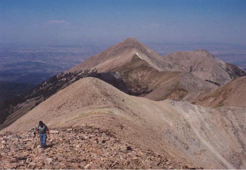
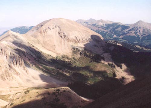
being steep but pleasant walking. Soon we reached the ridge with some great views into the basin below Peale, and
back west to the nearly perfect pyramid of Mount Tukuhnikivatz. The "Razor Fang" between Tuku and Peale was hidden by a nearer peak, called
"Talking Mountain".
We noticed dark clouds were already building over Peale, and were glad to see the peak was not far away. From here to the
peak is all rock, with some spots having a clear trail, others not. A short climb over a small but rocky peak gives way
to another false peak just before the final high point. Despite being tired from the incredibly steep hike, we made quick
progress to the summit, perhaps urged on by the growing clouds. I reached the summit a little before 11:00 am, making for just
under three hour hike up. The summit contained a small shelter with a summit log in
an old salsa bottle. I drank some gatorade and took the manditory summit photos of the nearby peaks, lonely South Mountain
to the south, Tuku with Moab in the distance, and the high peaks to the north including the range's second highest peak, bulky
Mount Mellenthin. Allen followed shortly behind me and we stayed for maybe 15-20 minutes. Another couple had also arrived
on the peak from Boulder, Colorado whom had climbed all the Colorado 14'ers and 13'ers! After a brief stay, it was time
to head back down. Hard to believe it was 100 degrees in Moab...with the wind it felt like it could snow any moment up on top
of Peale!
 The trip back down the rocky ridgeline was a little slow but easy. We followed the others down and found
a more recognizable trail than the way we had come up. A truly steep track led down through dirt and rocks
towards the gully, making for some of the fastest altitude loss I've ever done! Once back into the rock gully
it was a slow slog down the unstable rocks (with lots of black spiders!). We thought we had it made once we reached the bottom of the
rock gully (which seems like it could be infinately easier with snow!), but somehow we lost the trail
and had to do a little route-finding to get back to the jeep road we had come up. Along the way trying to find the route
back down we startled a deer, which along with a few pikas were the only wildlife we saw all day, though there were plenty
of markings on trees from the resident black bears. Once back on that, we headed
back towards our trailhead, this time finding the proper trail which leads very nearly back to La Sal Pass.
About five minutes after we got into the car, the rain started and we were very glad we had opted to begin
so early on the hike. From here it was a brief drive back to Moab to the hotel to clean up and get some
pizza. Going at a moderate pace (including some route-finding and photo stops), Peale took us about six hours round trip, climbing
about 2,600 feet in five miles roundtrip. The scenery was outstanding, and while I probably wouldn't go out of my way to do
Peale again, I would be interested in doing either Tukuhnikivatz from La Sal Pass or Manns Peak to the north (12,272') from Warner
Lake.
The trip back down the rocky ridgeline was a little slow but easy. We followed the others down and found
a more recognizable trail than the way we had come up. A truly steep track led down through dirt and rocks
towards the gully, making for some of the fastest altitude loss I've ever done! Once back into the rock gully
it was a slow slog down the unstable rocks (with lots of black spiders!). We thought we had it made once we reached the bottom of the
rock gully (which seems like it could be infinately easier with snow!), but somehow we lost the trail
and had to do a little route-finding to get back to the jeep road we had come up. Along the way trying to find the route
back down we startled a deer, which along with a few pikas were the only wildlife we saw all day, though there were plenty
of markings on trees from the resident black bears. Once back on that, we headed
back towards our trailhead, this time finding the proper trail which leads very nearly back to La Sal Pass.
About five minutes after we got into the car, the rain started and we were very glad we had opted to begin
so early on the hike. From here it was a brief drive back to Moab to the hotel to clean up and get some
pizza. Going at a moderate pace (including some route-finding and photo stops), Peale took us about six hours round trip, climbing
about 2,600 feet in five miles roundtrip. The scenery was outstanding, and while I probably wouldn't go out of my way to do
Peale again, I would be interested in doing either Tukuhnikivatz from La Sal Pass or Manns Peak to the north (12,272') from Warner
Lake.