 Mount Raymond is one of the higher and more popular peaks in the Wasatch.
It's summit affords one of the better views in the range. It's triangular
summit is visible from much of the valley below.
Mount Raymond is one of the higher and more popular peaks in the Wasatch.
It's summit affords one of the better views in the range. It's triangular
summit is visible from much of the valley below.
Mount Raymond is one of the higher and more popular peaks in the Wasatch.
It's summit affords one of the better views in the range. It's triangular
summit is visible from much of the valley below.
I've climbed Raymond a number of times, and it is one of my favorite peaks in the Wasatch. My favorite route is via Butler Fork/Baker Pass, but I've also climbed it from Mill B North Fork of Big Cottonwood Canyon and Bowman Fork from Mill Creek Canyon. All routes are rougly four miles each way, and gain between 3,000 to 4,000 feet.
From Butler Fork, it is about three miles to Baker Pass at 9,200 feet, 1,000 feet from the summit. Raymond is a much sharper summit than it's neighbor Gobblers Knob. The climb to Baker Pass from Mill B North Fork is much worse I thought. The trail is good for the first mile to an overlook, but fades in the heavy vegitation for a while before becoming more clear and bending back towards Mount Raymond. It is also steeper than the other options.
Bowman Fork in Mill Creek gains about an extra 900 feet from Butler Fork, but is on a good trail all the way to Baker Pass. From Baker Pass Mount Raymond is the sharp, obvious peak to the west. The mass on the east leads to the somewhat hidden Gobblers Knob. A faint track leads up steeply at first, then to an open, grassy ridge. Soon the ridge narrows to a rocky knife-edge. It's pretty easy for experienced hikers and climbers, but novices may be a little bit shaky as the ridge drops off sharply on each side. The rock is solid and easily climbed, but the nervous could easily straddle the 30 foot stretch of ridge with one leg on each side.
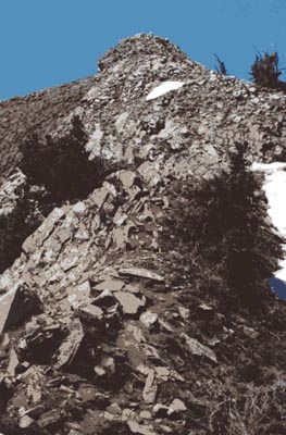
 From here, the peak is just about a 200 foot climb up broken rocks on
a faint trail. The peak offers great views in all directions including
a good view of downtown far below. South is the rugged Twin Peaks area (the picture
to the left is from lower on the trail). If coming up from Mill B North Fork it is possible to ascend the peak
via it's southwest ridge, but to my knowledge there isn't much of a
trail there. To the east you'll see Raymond's neighbor Gobblers Knob
just five feet higher.
From here, the peak is just about a 200 foot climb up broken rocks on
a faint trail. The peak offers great views in all directions including
a good view of downtown far below. South is the rugged Twin Peaks area (the picture
to the left is from lower on the trail). If coming up from Mill B North Fork it is possible to ascend the peak
via it's southwest ridge, but to my knowledge there isn't much of a
trail there. To the east you'll see Raymond's neighbor Gobblers Knob
just five feet higher.
The trip down is the same as the way up, being careful on the narrower section of the ridge. By July this east ridge of Raymond often has a lot of wildflowers adding to the scenery of the climb. It would not be too difficult to climb both Raymond and Gobblers Knob in one trip. The peak is usually snowfree sometime in June, but in years of heavy snowfall, the ridge may have some large slabs of snow remaining, so be careful then. Mount Raymond is in my opinion one of the five or six best peak climbs in the range.
2002 Update: After a two week layoff due to a long-lasting cold I made it back into the mountains for a climb of local favorite Mount Raymond. I did not start the day intending to climb Raymond, my plan was actually to make an ascent of Grandview Peak from City Creek Canyon, but when I arrived at the gate in City Creek, the ranger informed me that he didn't have the key to open the gate, and it could be an hour or more before they got the key (apparently another worker had taken it home accidentally). Since I didn't feel like waiting that long, I opted for another hike - Mount Raymond via Butler Fork.
 I could quickly feel the effects of the cold, and not hiking for a while. I struggled up
the Butler Fork trail more than usual to the junction where a branch to the left leads to
Circle-All Peak. I stopped for a rest and some photos here where the view back towards
Twin Peak Wilderness is so outstanding. To the northwest, only a few small patches of snow still
clung to Raymond. Continuing on the trail, I quickly reached the junction with the Mill
B trail where you go left (right leads towards Dog, Desolation Lakes). The trail has a gentle incline
for a long distance as it makes it's way to Baker Pass. Here I took another brief rest before
beginning the steep final push towards the summit. I could see a few hikers heading up and down both Raymond
and Gobblers Knob to the east.
I could quickly feel the effects of the cold, and not hiking for a while. I struggled up
the Butler Fork trail more than usual to the junction where a branch to the left leads to
Circle-All Peak. I stopped for a rest and some photos here where the view back towards
Twin Peak Wilderness is so outstanding. To the northwest, only a few small patches of snow still
clung to Raymond. Continuing on the trail, I quickly reached the junction with the Mill
B trail where you go left (right leads towards Dog, Desolation Lakes). The trail has a gentle incline
for a long distance as it makes it's way to Baker Pass. Here I took another brief rest before
beginning the steep final push towards the summit. I could see a few hikers heading up and down both Raymond
and Gobblers Knob to the east.
The trail grows more faint as it ascends the ridge, and I encountered about a 50 foot steep, but not too dangerous snowfield just before regaining the ridge. From here it was a nice walk along the long snowfield towards where the ridge becomes more rugged. A sharp knife-edge rises up, but is full of hand and footholds and easily climbed. The remainder of the ridge included some more scrambling mixed with parts of trail to the summit. Being 30 minutes later than I had hoped, I didn't stay long and headed back down. For whatever reason, the ridge seemed more rugged and rocky than on previous ascents I've done, but still nothing too severe. Still an outstanding hike!