Red Baldy sits on the Alpine Ridge seperating Little Cottonwood and American Fork Canyons. At 11,171 feet it is among the highest peaks in the Wasatch, but it sits between the higher American Fork Twin Peaks and White Baldy, thus, it sees relatively few ascents. Red Baldy is most commonly climbed from White Pine Canyon in Little Cottonwood via a number of routes, but it can also be climbed from the south by hiking to Silver Glance Lake, then routefinding up to "West Pass" between Red and White Baldy, and finishing via the west ridge (also accessible from the White Pine side via an endless boulderfield).
The most commonly described route appears to be the northwest ridge from White Pine Lake. I had attempted this route years ago, but didn't like the climbing up talus mixed with thick scrub trees and quickly abandoned the route. In 1999 I decided to try a route directly up the north face of Red Baldy. I got high up, but it was raining lightly and I turned back short of the true summit as it turns out. However, I had found that this northwest face route was easily the best, easiest route on this peak.
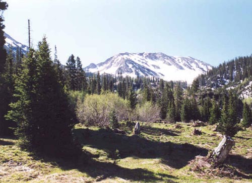
I returned with Allen this time determined to hit the true summit and get some photos. We took the standard hike up White Pine Canyon, which is quite popular. It is 5.1 miles to White Pine Lake, but you don't need to go all the way to the lake to do the northwest face climb. Follow the well-beaten old mining road to the last huge switchback easily visible on the face of Red Baldy. At the eastern end of the final switchback, look at Red Baldy and you'll see lots of loose rock and cliffs, but if you look at the northwest face, you can make an area of tundra that leads up very high on the mountain, and makes for the easiest, quickest way up this peak.
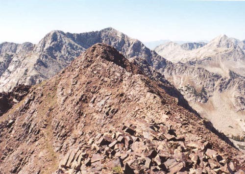
Look to Red Baldy's obvious north ridge and you can see a small patch of scrub trees high up before the ridge becomes all rock. Follow the steep tundra slope and work your way over to the ridge at these trees. Climbing the northwest face involves steep off-trail climbing on the tundra, but it is not really scrambling, and you should only need your hands for balance if you take the best route. We foolishly ascended up to within about 200 feet of the summit, and bypassed the ridge, opting to ascend straight up through the loose rocks making up the top part of this mountain. This was much more difficult as the rocks were very loose on the steep slope. When we descended the ridge, we found it to be a MUCH easier route than the rocks! The rocks on the upper part of Red Baldy are actually the reddish quartzite more commonly seen across the canyon on Cottonwood Ridge, as opposed to the granite found on White Baldy (and even lower parts of Red Baldy). As you ascend the face, be sure to take note of the ever-improving views to the west.
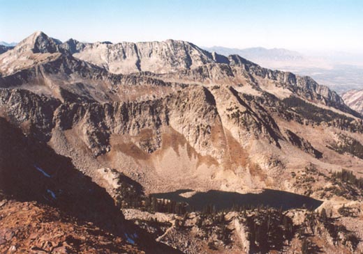
When we arrived atop the rocks there was a small field, perfect for a rest. We saw what we thought was the true summit a bit further to the west, but we soon realized after consulting the map that the rock piles above us led to the slightly higher true summit of Red Baldy. This was an easy climb from the tundra field. The western peak of Red Baldy is about 20-30 feet lower, and can be gained by scrambling the short ridge between the peaks. This slightly lower summit offers a better view of White Baldy. We stayed on the true summit only for a few minutes to take the standard pictures, but decided to retreat to the tundra field where we could relax more. The views were great, especially to the west down the canyon and towards Pfeifferhorn and Thunder Mountain. Red Stack and the American Fork Twin Peaks, the highest peaks in Salt Lake County dominated the view to the east. White Pine Lake was visible below, but was clearly lower than usual due to the ongoing drought in the west. The skies were incredibly clear, and we could see all the way south to Mount Nebo on this day. We found no mailbox or markers of any kind on the summit.
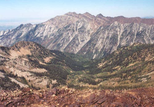
Back down in the field we saw another climber coming over the west peak and then over to the higher peak. He ended up following us down the northwest face route and remarked that it was definately better than the rocky ridge above White Pine Lake that he had ascended. Another hiker came up our ridge who was making an extended hike from Alta all the way to Maybird Gulch. Laying in the meadow, we took in the fine view across the canyon to Cottonwood Ridge and it's numerous avalanche chutes. This time we wisely started down the northwest ridge for about 200 feet where we could get into some tundra and walked the steep slope all the way back down (traversing to the west to avoid some cliff bands) to the White Pine trail below.
It took us just under eight hours to complete the hike, which is about 10 miles, and climbs 3,500 feet. Despite the rock scramble encountered on the way up, it was still a much easier climb than White Baldy which I had done a few weeks earlier. The east ridge of Red Baldy is much more rugged and is a difficult, exposed scramble. This would be accessed also from White Pine by gaining the ridge between Red Stack (part of American Fork Twin Peaks) and Red Baldy. Overall, an outstanding climb, and perfect if you've visited all of the more popular peaks and are looking for more solitude.
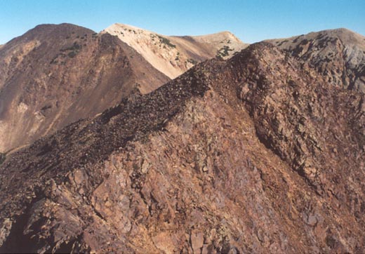
2003 Update: Made another ascent of Red Baldy. This time I ascended the north face the same as in 2002, but opted to traverse west over a pair of slightly lower false peaks, and drop down the northwest ridge to White Pine Lake. The hike to the base of Red Baldy was generally uneventful, with the exception of several deer sightings, and not one other hiker - the joys of hiking on weekdays! I climbed the north face's steep tundra slopes, trying to avoid getting caught in the loose quartzite rocks up high on the mountain. Even though I missed the rocks I got hung up in the year before, I still got stuck in a smaller area of steep, very loose rocks before reaching the northeast ridge, about 200 feet below the true summit. From this spot one gets a fine view of the particularly rugged east ridge that connects Red Baldy and the American Fork Twin Peaks. A small stick marked the summit.
I always regret not visiting sub-peaks, and not making the short trip over to the slightly lower west peak of Red Baldy (11,120'+) was one I wanted to knock off. The ridge looks a little intimidating, but wasn't too bad except for one tough move just before the false peak. From here, the unobstructed view of White Baldy I wanted was blocked by yet another peak, which was another 10 minute trip away (about here the rock changes to granite). By now I was pretty much committed to descending the northwest ridge, which I had partially climbed once several years earlier. After the last false peak I descended several hundred feet to near "West Pass", but not quite all the way there. I dropped off down some slopes of intermittent tundra and granite rocks. The slope gets even steeper here than my route up, and the sticky, thorny plants add to the difficulty. After what seemed like an eternity of boulderhopping and slow climbing down this hellish slope, I was back at White Pine Lake. All I can say is I'd take the north face route anyday over the northwest ridge! Back at the lake, I finally took a good, long rest and hiked the remaining five miles back to the trailhead. The traverse took just under eight hours.