Sundial Peak
Elevation: 10,320
Location: Wasatch Range, Utah
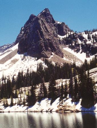 Sundial Peak is the prominent peak sitting directly behind popular Lake
Blanche in Big Cottonwood Canyon. It can be debated whether Sundial is
really a true "peak" or not. It is really a low point on a ridge leading up
to a nameless 11,033 foot peak, and it rises a mere 150 feet from the low
point along the saddle. But it's prominence above Lake Blanche and the rugged
climb required to get to the top seem to justify it as it's own peak to most
hikers and climbers. Sundial's north face is a technical climb.
Sundial Peak is the prominent peak sitting directly behind popular Lake
Blanche in Big Cottonwood Canyon. It can be debated whether Sundial is
really a true "peak" or not. It is really a low point on a ridge leading up
to a nameless 11,033 foot peak, and it rises a mere 150 feet from the low
point along the saddle. But it's prominence above Lake Blanche and the rugged
climb required to get to the top seem to justify it as it's own peak to most
hikers and climbers. Sundial's north face is a technical climb.
I climbed Sundial with the Wasatch Mountain Club. Myself and three other hikers
met at 8:30 at the Big Cottonwood park and ride, and we hit the trail just before
9am. The first part of the hike is the standard 3 mile, 2700 foot trek up to
scenic Lake Blanche. While I am a fairly fast hiker, I must say this group really
moved! Fortunately I was able to keep the brisk pace to the lake. The biggest threat
on this day was the persistant afternoon thunderstorms that had been plaguing the
entire state for the past week. By the time we got to the lake, around 10:30, some dark
clouds were already starting to build.
After about 10 minutes of rest we decided to continue up. The hike continues south around
the dam on Lake Blanche, and then a faint trail climbs towards the Sundial. The track fades
and we made a steep climb up grassy slopes and broken cliff bands. No place was particularly
dangerous, but I expect route finding could be challenging if you were not very familiar with
the area. Soon we were out of the steep area (a relief as I was really huffing and puffing now), and
began a much more gentle ascent up a wide, grassy valley. The Sundial ridge rose above us in
rugged fashion. We could see and hear two climbers just starting their descent from the summit.
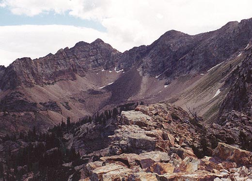 The climb to the ridge isn't too difficult except for a short talus crossing and a steep final
20 feet to the ridge, but there are excellent hand and foot holds all the way. Once on the ridge you
get a great view of how rugged an area you are in. The ridge is narrow and exposed on both sides.
After a short break I continued with Jim (the leader) towards the summit. The other two hikers were
slightly ahead of us. A steep initial rock was one of the most challenging parts of the climb. Careful
climbing was required as there were plenty of sharp cliffs below. One section required a tricky crossing
of a narrow, loose rock ledge on the east with a big rock jutting out forcing you to turn your body
somewhat away from the mountain...not confidence filling! Soon we finished a few easier parts (somewhat
like sidewalks, just with exposure) and arrived on the summit.
The climb to the ridge isn't too difficult except for a short talus crossing and a steep final
20 feet to the ridge, but there are excellent hand and foot holds all the way. Once on the ridge you
get a great view of how rugged an area you are in. The ridge is narrow and exposed on both sides.
After a short break I continued with Jim (the leader) towards the summit. The other two hikers were
slightly ahead of us. A steep initial rock was one of the most challenging parts of the climb. Careful
climbing was required as there were plenty of sharp cliffs below. One section required a tricky crossing
of a narrow, loose rock ledge on the east with a big rock jutting out forcing you to turn your body
somewhat away from the mountain...not confidence filling! Soon we finished a few easier parts (somewhat
like sidewalks, just with exposure) and arrived on the summit.
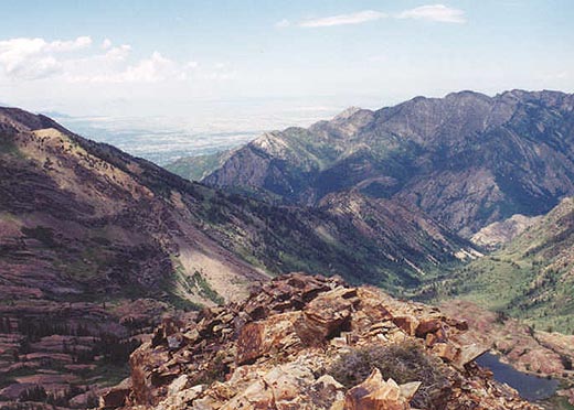
I was somewhat relieved to reach the peak, as much of the way I didn't feel I was up to it on this day. Part
of that might have been the fast pace however. We weren't on the summit long when we heard thunder echo in the
distance. Not wanting to be caught on this ridge during a lightning storm we only stayed on the peak for about five
minutes. I clicked pictures of the supreme views, in particular the rugged west face of the Mt. Superior/Monte
Cristo massif. Having had close calls with lightning in the past I must admit to a feeling of urgency to get
off of the peak. I scrambled quickly but carefully hoping to get off the dangerous part before a storm broke. Fortunately
for us it never did. Just as we got off the most difficult part it started to clear up. Here we took a longer break and
enjoyed the beautiful scenery.
 On the trip down we took a longer route that travels a more gentle valley (seasonal waterfall) to the west. Along
the way we saw many mountain goats on the rugged slopes above, and numerous marmots. This route down was in my
opinion much easier (save a few short talus slopes) than the way we took up. We took a nice break just before
reaching Lake Blanche and the maintained trail back down. We made quick time of the trail and were back at the car
just before 4pm, making it a roundtrip time of about seven hours. The stats for the climb are nine miles roundtrip roughly
with a elevation gain of about 4,150 feet. Sundial Peak is an outstanding climb, and similar in difficulty to nearby
Superior via Alta (probably not as difficult as Dromedary, Sunrise or Broads Fork Twins).
On the trip down we took a longer route that travels a more gentle valley (seasonal waterfall) to the west. Along
the way we saw many mountain goats on the rugged slopes above, and numerous marmots. This route down was in my
opinion much easier (save a few short talus slopes) than the way we took up. We took a nice break just before
reaching Lake Blanche and the maintained trail back down. We made quick time of the trail and were back at the car
just before 4pm, making it a roundtrip time of about seven hours. The stats for the climb are nine miles roundtrip roughly
with a elevation gain of about 4,150 feet. Sundial Peak is an outstanding climb, and similar in difficulty to nearby
Superior via Alta (probably not as difficult as Dromedary, Sunrise or Broads Fork Twins).