
Mount Timpanogos needs very little introduction. It is the second highest peak in the Wasatch Range, and with two excellent trails leading to its summit, it is probably the most famous mountain in Utah. The peak is huge. It is a nearly seven mile long mountain with numerous peaks over 11,000 feet. The north peak is a challenging objective for the climber bored with the trail hikes to the main peak. The peak is also home to the closest thing Utah has to a real glacier, and sliding down this snowfield is a popular way to descend the mountain.
As mentioned, the peak has two very popular trails, the Aspen Grove trail (about 7 miles each way, 4850 vertical) and the Timpooneke trail (about 7.5 miles each way, 4450 vertical). Both are very scenic.
I have climbed the peak twice from Aspen Grove and once from Timpooneke. I favor the Aspen Grove side, but it is exceedingly popular, and hiking it on a weekday if possible is highly reccomended for any amount of solitude. Timpooneke is only slightly less popular, expect crowds there also.
My first climb of Timp came in August of 1993. Myself and two friends, Dan and Patrick ascended the mountain from Aspen Grove. The hike begins with a sign warning of the risks of the mountain, which in springtime are very real as snow can collapse under hikers in a couple of sections of Aspen Grove. By August, this was no worry however.

The hike is gradual and paved for about the first mile to a waterfall, the first of many you'll see on this hike. The trail zig-zags up for a couple more miles passing by and thru waterfalls and keeping a gradual rate of incline all the way towards Emerald Lake, at 10,340 feet.
As you approach Emerald Lake, the summit of Timp starts to become obvious, as a nearly 1,500 foot cliff above the Lake. The tiny summit hut can be seen on the peak. Emerald Lake is an excellent and popular rest stop. In summer months on weekends there has recently been people stationed around the lake for medical purposes. In '93, it rained on us at the lake briefly, but cleared enough for a trip to the peak.
From Emerald Lake you'll have a fine view up the "Timp Glacier", and you'll probably be able to see people sliding down the snowfield. This is probably the most common cause for injuries on the mountain, as one of the medical people told me while bandaging my arm in '96 after a nice scratch I took sliding down the snowfield.

From the lake, the proper trail heads to the north to a saddle. Some adventurous climbers prefer to climb up the snowfield which isn't too bad but has a steep headwall that probably would require an ice axe. Following the trail towards that saddle I have encountered snow in both '93 and '96. It isn't difficult to cross, but be wary of the dropoffs should you slip waiting in the distance.
At the saddle, the trail meets up with the Timpooneke trail, and they share the same trail to the finish. From this saddle you'll now be able to look down into Utah Valley far below. In '96 on a saturday climb I ran into a hiker listening to a BYU football game on a walkman while climbing!

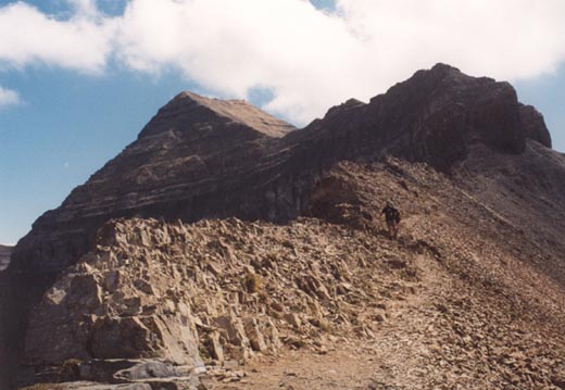
From this saddle, Timp's north face looks pretty intimidating, but you can see that the west face is steep but climbable. The trail begins to climb thru some small cliffs, and you'll admire the work done by the constructors in a few spots.
The last mile of the climb is spectacular. The trail seems to climb to the sky. Behind you is a good view down cliffs of the valley you climbed up from. The pointed metal summit hut soon comes into view and you'll probably be greeted by a fairly large crowd. In '93 we did the climb on a weekday and we passed just a handfull of other climbers. In '96, Dan and I climbed the peak on a saturday and it was like walking a busy city street in some parts. Even worse, in '98 I climbed a nearby peak called "Roberts Horn" on Labor Day.
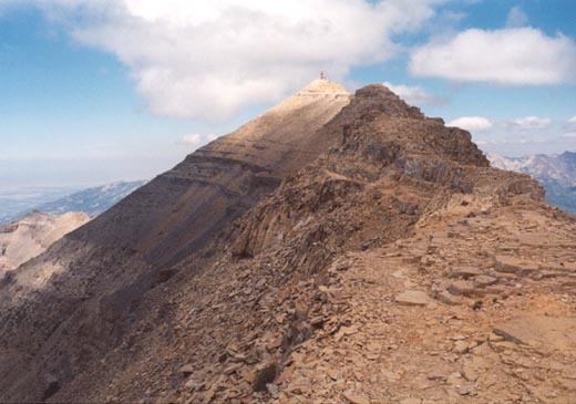
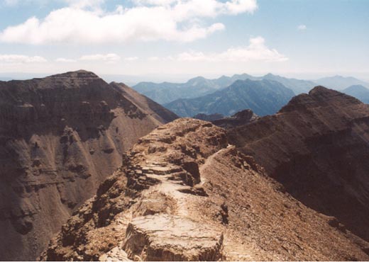
The view from the summit of Timp is excellent as you'd expect. The view to the north towards the peaks of the Cottonwood Canyon area is most impressive, you'll be able to make out Lone Peak, Pfeifferhorn, Broads Fork Twins, Sunrise and Dromedary. The view straight down to Emerald Lake below, where you'll see hikers looking like ants is also most impressive. The nearby southern peak of Timp is nearly as high as the main peak at 11,722 feet and is best climbed by following the trail to the saddle above the glacier and climbing that ridge. To the south far in the distance you should be able to see Mount Nebo, the only wasatch peak higher than Timp. Utah Lake is obvious to the west, and you'll probably be able to pick out numerous Provo landmarks far below you.

Sliding down the glacier is popular, but be prepared. The headwall is about 30 feet of very, very steep snow that gradually decreases in it's angle. You'll slide down several hundred feet in a hurry here! Probably the safest way down Timp is just to return the way you came up. It's long, as is the entire hike down, so be prepared to still spend a lot of time on this mountain.
In '94 I climbed the peak with Patrick via the Timpooneke trail, which is also very pretty. That trail ascends the "Giant Staircase" and passes very near the wreckage of an airplane. After miles of switchbacks up the very well maintained trail you'll arrive in Timpanogos Basin with a very impressive view of Mt. Timpanogos.
A toilet is nearby should you have the urge. You'll be able to see the glacier and pick out the bench where Emerald Lake sits. Follow the trail climbing eventually to the same saddle where the two peaks meet up. Again, the finishing climb up timpanogos is spectacular, and you'll understand why many people claim it to be the best hike in Utah.
The north peak of Timpanogos, at 11,441 feet is a considerably larger climbing problem that I hope to attain within the next year or two. Routes exist from the Timpooneke trail near the aircraft wreckage and from the west slopes, but any route on the north peak is much more difficult than the standard hikes and should not be taken lightly.
In '93 and '94 we completed the Timp hikes in a little under seven hours, but this is moving at a brisk pace. In '96 it was more like eight hours. Also, be prepared for a $3 charge (at this time) for use of the road that leads to both of the main trailheads. The road up Provo Canyon also gives a chance to see Bridal Veil Falls, the highest waterfall supposedly in the state of Utah.
2001 Update: In late October I made a solo hike up the standard Timpooneke trail to Timpanogos Basin for some photographs of the peak with early winter snows. Unfortunately I got an overcast day yielding very generic photos. The Timpooneke trail was clear of snow about halfway up to the basin, but soon it became covered with packed snow. The views back north towards Mill Canyon Peak and the Alpine Ridge were beautiful. By the time I was nearing the basin, it began to snow lightly, and with the stiff wind, it was pretty cold! I made it to the basin where fortunately I could still see the top of Timp before it became obscured in clouds. The "glacier" looked pretty empty from the dry winters and hot summers in recent years. Since I didn't really feel like hiking down in a snowstorm, my stay was brief, and I headed back down the long trail.
2003 Update: Made what is my fourth trip to the summit of Mount Timpanogos (among several other partial ascents, or ascents of other area peaks) over Labor Day weekend via the Aspen Grove trail. Safe it to say I had forgotten how pretty this mountain is, and how LONG the trail(s) are! I began up the Aspen Grove trail, which quickly gives way to a long stretch that is paved up to the first waterfall. The pavement goes away, and a few switchbacks lead to a second waterfall, both surprisingly strong this late in the year, considering the lack of snow, and extremely hot summer. After several switchbacks, including the one endless one that goes in the wrong direction, I began the climb up scenic Primrose Cirque. Amazingly a few rotted snow patches still remained. My hope on this hike was to climb the main summit of Timp, descend the trail over to "Glacier Saddle" and ascend the "Second Summit" which at 11,722 is only a few feet lower than the main Timpanogos summit. After several miles of hiking I could tell that might be just too long of a day for me at this point given a year of minimal hiking and, by my standards, poor conditioning.
Soon I was in the small basin before the main Emerald Lake basin. Being a sunday, the amount of hikers was minimal. Anyone who knows Timp knows saturdays and holidays are BUSY, and if you want much solitude at all, go on either a sunday or weekday. I got to Emerald Lake finally and was beginning to feel fatigued. I looked up to the "Glacier" and saw one of the saddest sights of my climbing life-- no snow! I've never seen this glacier (a permanent snowfield really) so low on snow, a sad reminder of how much we could use a really hard winter, and not such a hot summer.
I continued up towards the saddle where the Aspen Grove trail meets Timpooneke. Again, only tiny pockets of snow clung to the north face of Timp where usually it covers the rocks well into August, and in fact, this is the first time I've ever crossed this area on rocks! I huffed and puffed my way to the saddle and eyed what appears to be a faint trail that can be taken to the north (a possible future route to "North Timp"?). After another short rest, I started up the final switchbacks. I had forgotten how amazing these final switchbacks are in spots as they ascend up some fairly rugged sections! Soon enough I was on the top, where a large group was already enjoying the summit. Not wanting to listen to their conversation, I continued down the summit ridge to the south a ways in search of some additional pictures. A few mountain goats loitered below, but not close enough to get any good pictures. By now I had abandoned the idea of getting the "Second Summit", especially since the snowfield was gone, making the descent much tougher down the rocks, rather than sliding down the snow. As is often the case, darker clouds were building, and since someone had been hit by a lightning bolt on Timpanogos just two days earlier, I decided it might be time to get started down.
On the way up I briefly met a guy from Salt Lake who climbed Timp regularly on Labor Day weekend, something like 11 or 12 times. Because I'm so slow to write up this trip, I've since forgotten his name...but I met up with him on the summit and hiked back down with him. The trip down is a long one, so it was nice to have someone to talk with. My round trip time was a little over nine hours, which felt slow considering I used to do it in less than seven. I've seen several various distances for the two main Timp trails, and I'm guessing about 7 miles for Aspen Grove, and maybe 7.5 for Timpooneke (each way).