Willard Peak
Elevation: 9,764
Location: Wasatch Range, Utah
Willard Peak sits just beyond the much more popular Ben Lomond Peak near Ogden, but it is
Willard that is slightly higher and claims the title of highest peak in Weber County. With
a four-wheel drive vehicle one can drive very near to the summit from the north and make
an easy ridge climb. For those of us with regular cars, it is a 19 mile hike from North
Ogden Pass, over Ben Lomond to it's peak. To get there you'll want exit 352, Farr West.
 I did Willard in July of '98 as a warm up for the slightly longer day hike of Mount Whitney.
While the Whitney climb is definately harder because of the increased altitude and elevation
gain, don't underestimate the long hike to Willard, it takes a full day. The hike starts
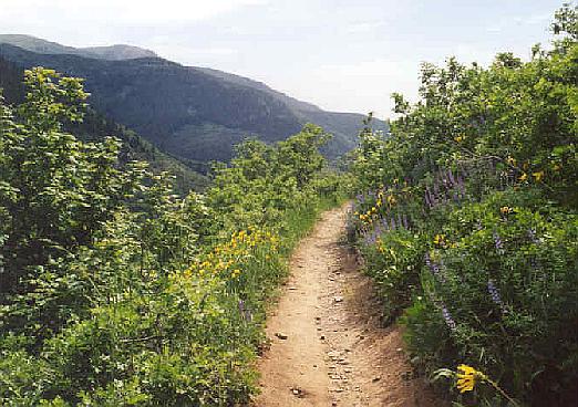
from North Ogden Pass and follows the Skyline Trail for eight miles to the popular summit
of Ben Lomond. From here you'll see Willard in the distance, a little over a mile away. A
trail heads down and follows the open, green ridge much of the way towards Willard, but
eventually drops and goes around the peak on the west. You'll have to find your way somehow
up to the peak up rocky slopes. I followed the trail and climbed a steep hillside of rocks
to reach the ridgeline again. Only one part was a little tricky near the end where the dropoff
to the east could be intimidating to a novice. From here it was a simple walk up broken
rocks to the summit.
I did Willard in July of '98 as a warm up for the slightly longer day hike of Mount Whitney.
While the Whitney climb is definately harder because of the increased altitude and elevation
gain, don't underestimate the long hike to Willard, it takes a full day. The hike starts
from North Ogden Pass and follows the Skyline Trail for eight miles to the popular summit
of Ben Lomond. From here you'll see Willard in the distance, a little over a mile away. A
trail heads down and follows the open, green ridge much of the way towards Willard, but
eventually drops and goes around the peak on the west. You'll have to find your way somehow
up to the peak up rocky slopes. I followed the trail and climbed a steep hillside of rocks
to reach the ridgeline again. Only one part was a little tricky near the end where the dropoff
to the east could be intimidating to a novice. From here it was a simple walk up broken
rocks to the summit.
From the peak you'll have a fine view west down sharp cliffs towards Willard Bay. From around
Tremonton the lower flanks of Willard (west side) have some tremendous cliffs. To the southeast
you'll see the triangular Ben Lomond Peak, which was still filled with quite a bit of snow
this early July day. The views back towards Ogden and Davis County further south are quite
impressive. A huge crack exists on the summit rocks, and I have no idea exactly what the
cause of this is. The ridge leading down to Willard Basin looks steep but not too difficult
should you come up the four-wheel route. The time from Ben Lomond to Willard and back to
Ben Lomond was probably about two hours, added on to the six or eight hours of the standard
Ben Lomond hike.
 The hike back also requires a short re-ascent of Ben Lomond before starting the final trip
down. I was lucky to have the pyramid of Ben Lomond still mostly snow covered on this hike
and had an easy, but steep glissade back down to the trail nearly 1,000 feet below the peak.
It is from this saddle that on the hike up you'll have your first view of Willard whether
you come up from North Ogden Pass or North Fork Park (shorter but steeper trail). By the
last few miles I was growing quite tired of the walking, and I was surely happy to get back
to my car.
The hike back also requires a short re-ascent of Ben Lomond before starting the final trip
down. I was lucky to have the pyramid of Ben Lomond still mostly snow covered on this hike
and had an easy, but steep glissade back down to the trail nearly 1,000 feet below the peak.
It is from this saddle that on the hike up you'll have your first view of Willard whether
you come up from North Ogden Pass or North Fork Park (shorter but steeper trail). By the
last few miles I was growing quite tired of the walking, and I was surely happy to get back
to my car.
Willard was a good climb, but more than likely I'd return and do only Ben Lomond, or I'd
climb Willard from the much shorter route from Willard Basin/Campground. Nevertheless, climbers
of the highest peak in each county will probably have to make the long haul to obtain this
peak.
2002 Update: Not an official climb, but I drove with my friend Justin up the Willard Basin road
to the summit of Willard Mountain. This is surely the easiest way to access both Willard Peak
and Ben Lomond Peak. The road is long and dusty, and since the basin is north-facing, expect snow patches
to linger well into the summer. The road is popular with ATV's and motorcycles.
 The road heads south from the town of Mantua and is a fairly good dirt road for the first few miles, but
beyond that it gets rougher and passenger cars will struggle getting past some spots. I do not
reccomend taking a passenger car up this road very far. Fortunately we were in Justin's higher clearance
vehicle and had no major problems. The road winds all over the place as it climbs higher. It is a good 11 miles
to Willard Basin, where the road makes a large "U" as it goes south, then back north towards Willard Mountain. For
a climb of Willard you could park at Willard Basin which is signed, and has decent parking space. Willard Basin is at
an elevation of 8,800 feet. Walk south on the trail past a small pond, then up to the ridge where the main trail leads just below Willard Peak towards Ben Lomond. Simply
routefind up the steep slope of grass and intermittent rocks to Willard's summit. You could also climb directly up the northwest
ridge, but that involves some scrambling.
The road heads south from the town of Mantua and is a fairly good dirt road for the first few miles, but
beyond that it gets rougher and passenger cars will struggle getting past some spots. I do not
reccomend taking a passenger car up this road very far. Fortunately we were in Justin's higher clearance
vehicle and had no major problems. The road winds all over the place as it climbs higher. It is a good 11 miles
to Willard Basin, where the road makes a large "U" as it goes south, then back north towards Willard Mountain. For
a climb of Willard you could park at Willard Basin which is signed, and has decent parking space. Willard Basin is at
an elevation of 8,800 feet. Walk south on the trail past a small pond, then up to the ridge where the main trail leads just below Willard Peak towards Ben Lomond. Simply
routefind up the steep slope of grass and intermittent rocks to Willard's summit. You could also climb directly up the northwest
ridge, but that involves some scrambling.
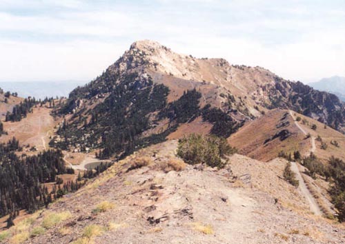
A better route still is to finish the drive all the way to Willard Mountain's summit (not to be confused
with Willard Peak) at 9,422 feet. The views from this summit are incredible, though there isn't much room
for parking. Look to rugged Willard Peak and descend the ridge, on a trail to where the trail meets the trail
coming up from Willard Basin, then follow the above route to Willard Peak, or continue on the trail past Willard
Peak towards Ben Lomond. Thanks to Justin for putting his vehicle thru the abuse required to get up to this
scenic area!